Make the most of today
Victorian Surf Forecast by Craig Brokensha (issued Friday 31st December)
Best Days: Today, tomorrow morning exposed beaches, possibly Wednesday/Thursday mornings east of Melbourne (check back Monday)
Features of the Forecast (tl;dr)
- Small, weak SW swell tomorrow with mod-fresh N/NE winds, shifting SW by late morning
- Light-mod SE tending S/SW winds, then strengthening Sun
- Small, weak W/SW swell Mon and Tue with fresh S tending stronger PM winds (S/SW Mon and S/SE Tue)
- Mix of SW and SE swells Wed with gusty SE winds
- Mid-period SW swell kicking late Wed, peaking Thu with gusty SE winds (possibly E'ly in the AM east of Melbourne)
Recap
Our new pulse of mid-period SW swell provided a touch more size than expected yesterday and even into this morning as it eases. The Surf Coast saw 3ft sets with clean conditions across most breaks, best on the beaches though, while the Mornington Peninsula saw 4-5ft sets.
Today the surf is still 2ft on the Surf Coast and 3ft+ to the east with a moderate offshore wind. We'll see conditions remaining clean into the early-mid afternoon ahead of late sea breezes.

Good conditions yesterday
This weekend and next week (Jan 1 - 6)
The start of the New Year will see clean conditions across exposed beaches with a moderate to fresh N/NE breeze, though minimal levels of swell.
A poorly aligned front moving through our swell window yesterday (south-west of us) might keep inconsistent 1-2ft sets hitting the Surf Coast magnets with 2-3ft sets to the east, though keep your expectations low.
A trough will bring a SW change by late morning and this will signal a start of poor surf with strong onshore winds that will persist until at least mid-next week.
Therefore make the most of today and get in for a morning surf tomorrow ahead of the change.
The synoptic setup responsible for the poor run of persistent wind will be strong high pressure ridge trying to move in from the west, though held off by a tropical low dipping south into the Tasman Sea, squeezing the pressure gradients across our region.
 Sunday morning looks to see light to moderate SE winds but with no decent swell, shifting S/SW through the morning and strengthening into the afternoon and evening. Monday will then see fresh S'ly winds, strengthening from the S/SW through the afternoon with a shift to SE winds on Tuesday.
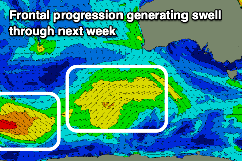
This will spoil a couple of swells, the first being weak and out of the W/SW on Monday and Tuesday, generated by a weak frontal progression pushing up and under Western Australia today and tomorrow. A slightly stronger trailing low looks to produce a better SW swell for late Wednesday and more so Thursday morning. Size wise at its peak it looks to come in at 3ft+ on the Surf Coast and 4-5ft+ to the east.
During Wednesday and at the peak of this swell there'll be some poor SE windswell in the mix owing to the strong SE winds through Bass Strait.
 Winds look to persist out of the SE on Wednesday though we may see a period of lighter E'ly winds through the morning across the Mornington Peninsula, similar on Thursday. We'll have to look at this again on Monday though as the models diverge regarding the track and position of the low moving down the East Coast.
Unfortunately the blocking high will prevent any major swell generating systems forming in our close-medium swell window through next week, resulting in a small run of weak swells and with what looks to be average winds as high pressure dominates our latitudes. There might be a more distant swell from a broad polar low late next weekend but more on this Monday and have a great New Year!


Comments
Happy New Year Craigoss. Appreciate it!
You too Bone! Hopefully see you in the New Year!