Fun weekend across the beaches
Victorian Surf Forecast by Craig Brokensha (issued Friday 10th December)
Best Days: Tomorrow morning east of Melbourne, Sunday morning on the beaches, Monday exposed breaks, dawn Wednesday east of Melbourne, Friday east of Melbourne
Features of the Forecast (tl;dr)
- Moderate sized S/SW groundswell arriving this afternoon, easing slowly tomorrow with light E/SE tending mod-fresh SE winds
- Reinforcing, smaller S/SW swell Sun with E/NE winds, tending variable ahead of sea breezes from mid-afternoon
- Fading surf Mon with NE winds
- Small, weak W/SW swell for later Tue, peaking Wed AM with early variable winds, tending SW mid-morning
- Inconsistent W/SW groundswell building later Thu, peaking Fri AM with light E/NE winds
Recap
Poor surf all around the last two days with 3ft of junky windswell on the Surf Coast yesterday, larger and to 4ft or so to the east, smaller and weaker today with a fresh, persistent S'ly wind.
This weekend and next week (Dec 11 - 17)
Into this afternoon we should see our new S/SW groundswell filling in, generated by a strong polar low firing up under the country earlier this week. The swell should kick wave heights to 3ft+ across the Surf Coast and 4-5ft to the east, with it easing back through tomorrow slowly from 3ft and 4ft respectively.
 Winds are looking better for the beaches east of Melbourne tomorrow morning with a light E/SE breeze, shifting SE and increasing through the afternoon.
The easing trend into Sunday will be slowed by a reinforcing S/SW swell, generated by a good polar frontal system pushing in behind the low. This front is currently passing under Tasmania and we should see it maintaining 2-3ft waves on the Surf Coast with 4ft sets to the east as winds improve further, shifting E/NE and holding until early afternoon ahead of a SE sea breeze.
Monday will be fun all day on the beaches with a persistent NE offshore wind and small easing swell from 1-2ft on the Surf Coast and 2ft to occasionally 3ft to the east.
A trough looks to bring a SW change into the evening and this will leave SW tending SE winds on Tuesday but with no new swell.
Into Wednesday we've got a small pulse of weak W/SW swell due across the state, generated by a weak trough forming into a low under the Bight on Monday, generating a fetch of strong W/SW winds before dipping south-east across Tasmania.
The swell should build later Tuesday but peak Wednesday morning with easing sets from 2ft+ on the Surf Coast and 4ft to the east. The timing of a secondary trough moving through looks tricky but we should see variable winds early Wednesday before shifting SW again through the morning.
 This will then write off the surf into Thursday with gusty S/SW winds due along with a weak, easing swell.
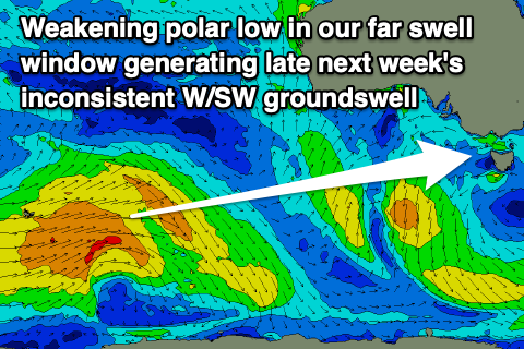
Friday may see winds shift back to the E/NE but we'll have to confirm this on Monday. Swell wise, an inconsistent W/SW groundswell should build Thursday and then peak Friday morning, generated by a strong though distant polar low that's currently south-east of South Africa.
This low will produce a great fetch of gale to severe-gale W'ly winds while pushing east across the Heard Island region over the coming days, weakening south-west of Western Australia. A very inconsistent swell is expeced that is only likely to come in at 2ft+ across the Surf Coast with 3-4ft+ sets to the east. Following this a secondary pulse of inconsistent W/SW groundswell is likely next weekend with light winds, but more on this Monday. Have a great weekend!


Comments
I look at these reports peeking between my fingers lately like a gruesome horror story. This is not as bad as I was expecting...
Deja vu to last Monday. 934 low next weekend looks good. That's a massive storm
Surely we are due. Will all the other planets align? Frothing for the coming weeks forey
Mm mm 920 low pressure storm after the mid lat low. Swell of the year incoming?!?
Just looked on ECMWF and ho ho ho
I've been saying merry fking Xmas over and over again in my head
Santa's dustin' off the guns for Xmas
Jeez poo man you’re very excited for something a long way out. Setting yourself up for disappointment I think!
Not getting my hopes up for 10/10 waves because I don't like surfing around here if it's over 4 metres. I can only hope we get more smaller days then big days with this LWT