An improved outlook with more favourable winds
Victorian Surf Forecast by Craig Brokensha (issued Friday 19th November)
Best Days: Saturday, Tuesday, Wednesday
Features of the Forecast (tl;dr)
- Building mid-period S/SW swell tomorrow with light S/SE winds (possibly SE at periods east of Melbourne), tending moderate S'ly into the afternoon
- Easing S/SW swell Sun with moderate S'ly winds, freshening
- Mix of S/SW swells Mon with moderate SE winds, freshening through the day
- Easing SE windswell Tue with a building S/SW groundswell later in the day with N/NE winds
- Easing S/SW groundswell Wed with N/NE tending variable winds
Recap
While the swell was tiny on the Surf Coast yesterday, conditions were clean and fun for beginners on the beaches, while to the east, a small background swell provided 2ft to occasionally 3ft waves with all day offshore winds. There were fun options all over.
Today a change has moved through with a weak trough bringing a little kick in localised swell and onshore winds.

Fun surf yesterday afternoon
This weekend and next week (Nov 20 - 26)
Tomorrow is now looking a lot more doable across the coast, with a less favourable S/SE breeze, but only light in the morning and moderate into the afternoon from the S'th.
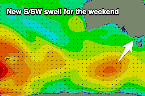
 This will be as the trough moving through last night lingers in the region. Our good pulse of new, mid-period S/SW swell is on track, with the frontal system linked to it currently pushing under Tasmania.
We should see the swell building through tomorrow and likely coming in at 2ft+ on the Surf Coast in the morning, 3-4ft on the Mornington Peninsula, building to 3ft and 4-5ft respectively into the afternoon with the odd bigger one possible on the Surf Coast magnets.
The swell will ease into Sunday and winds will freshen while hanging from the S'th, creating bumpy, average conditions.
The low that was forecast to develop east of us in the Tasman Sea now looks to be a little further north in position which will mean it won't squeeze as hard on a high sitting to our south-east, bringing the forecast strong south-east winds and the expected south-east windswell Sunday/Monday.
Instead moderate SE winds are due Monday, freshening through the day with a small afternoon pulse of S/SW swell, but to no major size.
 As the low slips south Monday winds are expected to strengthen through Bass Strait into the evening, producing a small spike in SE windswell for Tuesday morning. Winds will improve though and shift around to the N/NE now and remain so all day, but size wise we're looking at 2ft+ waves on the Surf Coast and 3-4ft sets to the east.
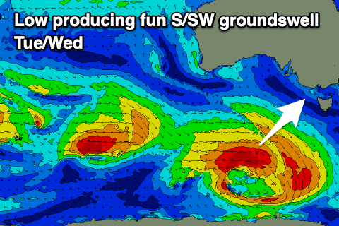
A stronger, S/SW groundswell should arrive into the afternoon though, generated by a strengthening low dipping south-east under the country through the weekend. A great fetch of gale to near severe-gale W/NW winds will be aimed through our southern swell window, with a good kick in size due to 3ft+ on the Surf Coast late in the day, 4-6ft to the east.
Conditions look to remain favourable on Wednesday as the swell eases with a N/NE offshore again ahead of weak, if not variable sea breezes. The next trough moving in from the west will push through Thursday, bringing a strong SW change with some smaller pulses of mid-period W/SW-SW swell.
We'll have a closer look at this on Monday though as the models are moving around a bit with all the instability and troughy weather pushing in from the north and west. Have a great weekend!


Comments
Look at that 1-2 weeks of easterlys just before December. That's The transition into summer, right on time. We just need all that la nina moisture from up north to fuck off by the end of December. Then we may actualley get 2 months of proper hot summer conditions here on the surfcoast
All roads lead to the M.P and P.I for some decent surf between now and end of year.
Turd polished.. !
Um, Craig, 15 degrees next Friday?!!?!
You should be ashamed of yourself…