Pick the winds and swell pulses this period
Victorian Surf Forecast by Craig Brokensha (issued Friday 1st October)
Best Days: This morning, Sunday, Wednesday, Thursday morning on the beaches, Friday protected spots
Features of the Forecast (tl;dr)
- Moderate sized, mid-period S/SW swell building later this afternoon, easing tomorrow with moderate SW winds, freshening through the PM
- Easing S/SW swell Sun with local offshore winds
- Low point in surf with strong N/NW tending W/NW winds
- Weak W'ly swell Tue with strong SW winds
- Smaller Wed with NW tending NE winds
- Better W/SW swell building Thu with NE tending strong SW winds, peaking Fri AM with strong W/NW winds
Recap
What a dynamic 24 hours. A slow moving, broad low shifted this way and that through yesterday with early E/SE winds easing and tending more E'ly allowing conditions to improve across the Mornington Peninsula and Phillip Island during the morning. There was a solid mix of swells in the 4-6ft range, deteriorating into the afternoon as fresh S/SE winds kicked back in.
Overnight we've seen the low pressure centre drift west-southwest, bringing offshore winds from the north-eastern quadrant to all locations and a peaky mix of swells to an inconsistent 4-5ft on the Mornington Peninsula and 3-4ft on the Surf Coast.
Make the most of these conditions as winds will shift south-east from late morning.


Inside, outsides
This weekend and next week (Oct 2 - 8)
We've seen moderate sized pulses of S/SW swell underneath the localised SE windswell yesterday and this morning, and we've got one more pulse due late this afternoon.
These swells have been generated by frontal systems swinging in from the southern Indian Ocean, producing not overly strong, but broad fetches of strong to gale-force W-W/NW winds along the polar shelf, under the country.
Later this afternoon's should keep inconsistent 3-4ft sets hitting the Surf Coast with 4-6ft sets to the east, easing back through tomorrow from an infrequent 3ft+ and 4-5ft+ respectively.
Winds are the main issue, with the low centre moving south-east, bringing moderate SW winds to most locations, strengthening through the day and shifting more S/SW on the Surf Coast. There's a decent chance for lighter W-W/SW winds early on the Surf Coast but they won't last long.
Sunday is still looking really fun across both regions with a light N/NW-N breeze on the Surf Coast and moderate N/NE winds to the east along with easing surf from 2ft+ west of Melbourne and 3ft to possibly 4ft on the Mornington Peninsula. Winds look to remain favourable into the afternoon so make the most of this before conditions deteriorate into next week.
Into next week we'll see a series of relatively weak mid-latitude fronts pushing in from the west and south-west, creating tricky and windy pulses of westerly swell.
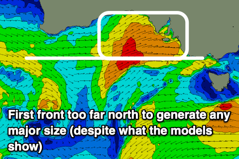
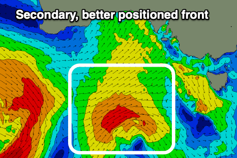
 The track and structure of each look hit and miss, with the first pushing too high through the Bight, north of our swell window, while the second is much better aligned.
Looking at the first system, and it will be quite strong, with gales projected into South Australia, with a slim fetch aimed through our swell window briefly Monday before pushing across us Tuesday.
With this, I'd keep your expectations low regarding size, with the mid-period, weak W'ly swell from this source due to fill in Tuesday along with a strong SW change. The Surf Coast might see 3ft surf with 4-6ft waves to the east (under the model forecasts).
The swell will drop rapidly into Wednesday as winds shift back to the NW, tending NE into the afternoon ahead of the next front.
 The Surf Coast looks to ease from 2ft with 4ft sets to the east.
This secondary front is a little better positioned but still relatively weak and we'll see fetches of strong to gale-force W/SW winds projected towards us through early-mid next week, generating a moderate sized, mid-period W/SW swell for Thursday afternoon and Friday.
Early NE winds will give into a strong SW change Thursday as the swell generating front moves through, shifting back to the W/NW on Friday. Size wise we're looking at surf in the 4ft range across the Surf Coast, 6ft+ to the east, but we'll have a closer look at this on Monday. Have a great weekend!


Comments
Hey Craig, surf forecast models showing light s/e winds but you have forecast moderate SW strengthening into the arvo. Just wondering as I'm going for a fish and my fav spot likes a Se but not a moderate SW.
When's this? Also not a cryptic surf spot question? Haha
Sorry, tomorrow mate. Just looked at WillyWeather and they are calling light w/sw for most of the day.
Nothing cryptic here! Just heading out in the boat and need a s/easter or light winds.
Yeah moderate SW, lighter from the southern end of the peninsula to the Prom through the morning then moderate S/SW into the PM.
Cheers Craig
How's the humidity we've had the last few days, no need to travel to a subtropical location, the weather has come to us :)
Yep, also notice the low clouds seemingly moving fast? Ah the tropics