Very active period ahead
Victorian Surf Forecast by Craig Brokensha (issued Monday 20th September)
Best Days: Wednesday, Thursday, Friday, early Saturday, Sunday morning
Features of the Forecast (tl;dr)
- Mod-large mid-period W/SW swell building this afternoon with strong W-W/SW winds
- Large W/SW groundswell peaking tomorrow AM, easing into the PM and Wed with strong SW winds tomorrow, easing a touch and tending W/SW mid-late afternoon
- Moderate W/NW winds Wed AM, tending variable into the PM
- Small mid-period SW swell arriving late Wed PM
- Stronger SW groundswell building Thu, peaking into the PM with strong NW winds, easing a touch and tending W/NW into the PM
- Easing SW groundswell Fri with strengthening N/NW tending W/NW winds
- Mid-large SW swell for Sat with early W/NW tending strong SW winds, easing Sun with W/NW tending SW winds
Recap
Our inconsistent and distant SW groundswell due Saturday didn't really show with any size at all across the coast. It wasn't the most reliable swell, but still wave heights struggled to get above 2ft on the Surf Coast where it was cleanest.
Sunday started a touch slow as well with our new, moderate-large sized mid-period W/SW swell coming in a touch delayed. It did fill in through the morning though with some great waves reported both east and west of Melbourne before winds shifted more NW and stronger into the afternoon, favouring protected spots.
Today the swell is holding around 3-5ft on the Surf Coast, 6ft+ to the east with gusty W/NW winds. We should see larger levels of mid-period W/SW swell building through the afternoon as winds shift W-W/SW. More on this below.
This week and weekend (Sep 21 - 26)
 Yesterday's mid-period W/SW swell was generated by the first of two lows firing up under the country late last week and over the weekend. This afternoon's building mid-period W/SW energy ahead of some stronger groundswell tomorrow morning are linked to the second low.
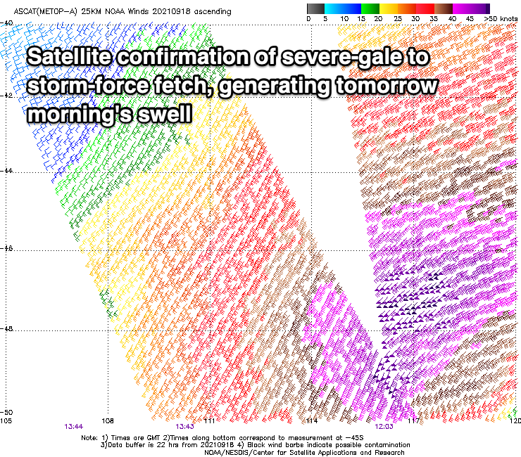
This second low formed a little further south compared to the first, but was mainly positioned in our western swell window. With this low acting on top of the active sea state of the low before it, it requires less energy to kick up a larger open ocean sea state. So with a fetch of severe-gale W/SW winds (reaching storm-force at times) projected towards us through the weekend, weakening on approach today, we'll see a large W/SW groundswell arriving overnight and easing tomorrow. Ahead of this this afternoon though we'll see moderate-large mid-period energy arriving, building to 4-5ft+ on the Surf Coast and 6-8ft to the east as winds shift W-W/SW.
Tomorrow morning should reveal the most size with 6ft waves on the Surf Coast, 8ft to the east, easing through the day.
Unfortunately the backside of the low will project strong SW winds up into us overnight, leaving strong SW winds across the coast tomorrow morning, shifting more WSW into the afternoon while easing a little in strength, creating a slight improvement in conditions. There'll also be moderate amounts of S/SW swell in the mix from this trailing fetch.
Conditions should improve further into Wednesday morning with a W/NW offshore, and weak, variable sea breezes. Size wise the W/SW groundswell and mid-period S/SW swell will be back to 3-4ft on the Surf Coast, 5-6ft to the east.
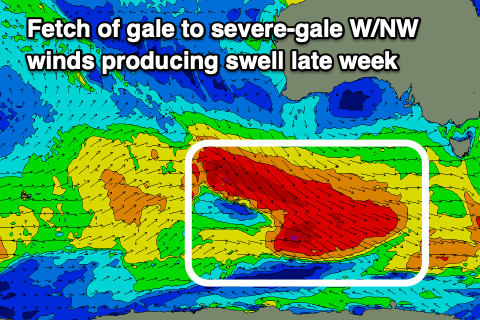
 Later in the day some new mid-period SW swell may be seen, generated by an initial fetch of W/NW gales firing up in our south-western swell window, south-southwest of Western Australia today, but this will be the precursor to a more significant fetch of severe-gale W/NW winds moving under the country tomorrow, producing a larger SW groundswell for Thursday/Friday.
While not ideally aimed through our swell window, its placement southward towards the polar shelf should allow for some decent sized swell to spread radially up and into us.
Later Wednesday's swell looks to be below the size seen in the morning, but come Thursday we'll see the groundswell building gradually through the day. The morning looks to be 3ft to possibly 4ft on the Surf Coast, 4-5ft+ to the east, but increasing to a strong 4-5ft and 6-8ft respectively into the afternoon.
Friday morning looks to be a little smaller, likely easing back from 3-5ft and 6ft+ respectively to the west and east.
 Winds look favourable for protected spots still, with a strong NW breeze Thursday morning, easing a little and shifting W/NW into the afternoon, then strong N/NW early Friday, shifting W/NW while increasing further ahead of a late W/SW change.
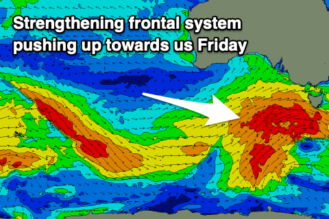
This strengthening wind will be linked to a strengthening frontal system on the back of the activity generating Thursday/Friday's swell. A great, broad fetch of W/SW gales are forecast to be projected north-east through our south-western swell window, producing yet another moderate sized + swell for Saturday. This looks to be around 4-5ft+ on the Surf Coast and 6-8ft to the east along with early W/NW winds, tending strong SW mid-late morning. More on this in the coming updates though.


Comments
love this from you craigos
torquay in lockdown, and with the winds looks like #@$#, #@$#, #@$#, #@$#, #@$# #@$# shouldnt be that crowded and tides are okay hope l havent given any secrets away
No need to name names Chris, I've edited out the details.
Hey Craig, cheers for monitoring this, I have recently noticed we don't have the ability delete ur own comments anymore, is that by design or mistake.
Agh, yes, I forgot that's a new function.
Some top notch work from you Craig, as for you CT, keep the crowds low comrade
Cheers woops l suppose that part of the coast is a bit under the radar in certain conditions l know you can have an empty surf there sometimes even though they are named in that great book surfing victoria
No problems Chris, just good to keep spots on the down low.
Woops Thanks good work kinda secrets still as conditions have to come together
Doesn't Torquay's surfing population usually double during lockdown?
Yes but when the waves are falling out of the sky, the crowd tends to thin out by about 80%.
Every cloud has a silver lining... Torquay's latest lockdown incuded. See you all in the water gentlemen : )
How will we recognise you sheep shagger? Do you like have custom-made wetsuit gloves with velco?
I think we all agree that Chris T must be a wanker. Hopefully he will graduate when he learns how to surf and learns the etiquette of the high seas
A bit rough denchy not many secrets between Lorne and Apollo road follows that great ocean of ours ..still shouldn't done it.... l am sure we traded waves on our stand ups out at outers on a 2 to 3 ft day musta caught 30 waves each
CT I wouldn't worry about it any secrets on the west coast were gone by around 1976 I reckon and now that the population has probably doubled or tripled it is even worst. It is so accessible it is a no brainer compared to the NSW coast where you have to drive in for miles to get to spots then back out to get around the rivers and lakes.
True memlasurf Richard loverage has most in his great book surfing vicco ...past Apollo there is the odd secret held to by the locals with crazy access you need to know. love that stretch have been told a couple.. that cats not coming out the bag
Hey Chris you are a f#$&ing wanker, you're not funny at all
RL's book hasn't got half the waves in it, and even Bells gets uncrowded from time to time, so best just shut up, CT.
I wonder why these forums are not more private. I mean too many cry baby blow ins from Melbourne and arrogant blow ins from Torquay for the last 2 years
How many Hi Lux Utes do you reckon you can cram into a Surf Coast beach car park? Unless you surf at midnight, no spot will be uncrowded for the next two weeks.
I just came back from a very well known S.C beach now.
Car parks everywhere.
Count your blessings Ringo. I should have added 'dependent on surf conditions.' Hope you got a couple.
Nah....just taking the dog for a run in pumping onshore wind but geeez it's nice to be down there without a million other f##kers. Only a couple of other humans in sight today.
Earthquake Vic appr 9:16am, plates in kitchen and clothesline shook here.
6.0 centred Mansfield?!
https://earthquakes.ga.gov.au/
Has anyone tested out their local in a tsunami before? Gonna sit and wait under the ledge and hopefully get the wave of me life
Sort of - a nice family beach day at Gero back beach Boxing day 2004. It was my youngest's first surfing day, he was on this tiny thruster getting great little waves. Tsunami was on the way and came up to 1.2m that night, knocking some fishos off the jetty at Gero marina.
Would be interesting to see how a swell (alleged Tsunami) coming from the SE in Bass straight would unleash on the Bells Bowl. Bells turns into Shark Island!!!
Felt here in Sydney for 15s or so, weirdest feeling, dizzy like and I only figured it out once I check the water on the desk.
Yeh, was a strange feeling down here
Made a thread here: https://www.swellnet.com/forums/wax/525381#comment-763050
"Very active period ahead", you nailed it in the forecast, Craig. I was sitting in my car in the backyard on the SC with the engine off and the car started to gently rock. Very strange feeling indeed. Lasted 10 or 15 seconds.
I'm in Jan Juc. Felt/heard nothing.
Feel like I'm missing out.........
That was fucked Craig, don't do that again please. Haha. A geologist once told me that we are on a fault line in the Otways and it comes out at Bird Rock!
Haha, heavy!
Yeah I knew about the multiple small fault lines around Otways/SC, never thought I'd be in a quake tho!
It was all time at Pier 3182 after that quake this morning. Lucky no surf coast superspreader blow ins out there today, genuine locals only conditions.