Lots of swell to come with favourable winds for protected spots
Victorian Surf Forecast by Craig Brokensha (issued Wednesday 11th August)
Best Days: Protected spots all period, likely best Saturday AM
Features of the Forecast (tl;dr)
- Inconsistent W/SW groundswell for tomorrow AM, with a similar sized, slightly more consistent mid-period W/SW swell for the PM, easing Fri
- Fresh NW tending W/NW winds tomorrow and Fri
- Mod-large W/SW groundswell for Sat AM, easing later with mid-period easing SW swell Sun
- Fresh NW winds Sat, stronger NW Sun
- Large SW groundswell building Mon (peaking PM) with fresh W/NW tending strong SW winds, easing Tue with fresh SW winds (W/NW early west of Melbourne)
Recap
Easing surf with favourable conditions for all regions yesterday, dropping from 2ft on the Surf Coast and 3ft to the east. This morning the swell has reached a low point with clean conditions across most locations early, though an approaching front will tip winds more NW through the afternoon.
This week and weekend (Aug 12 - 15)
Following this morning's low point in swell, very late in the day we may see the forerunners of long-period, W/SW groundswell but tomorrow is when the bulk of the size is due across the state.
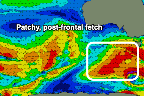
This groundswell was generated by a significant but distant polar frontal progression pushing up and towards Western Australia, with it being very west in nature and very inconsistent. Expect slow 3ft waves across the Surf Coast with the odd 4ft'er on the swell magnets, with 5-6ft waves to the east.
Into the afternoon a slightly more consistent, though weaker and still slow, mid-period W/SW swell is due to fill in, generated by the weakening frontal progression, slipping east-southeast across Western Australia and into the Bight. Weakening W/SW gales have been aimed towards us, with them currently strong, under South Australia.
 Surf to 3-4ft and 5-6ft+ respectively is due across both coasts into tomorrow afternoon, easing back from 3-4ft and 5-6ft Friday morning. Winds will be ideal for protected locations and fresh from the NW tomorrow, shifting W/NW into the afternoon, similar Friday.
We then look at our frontal system come polar low that's due to generate swell for the weekend and there's been a slight change in the structure and strength of this system.
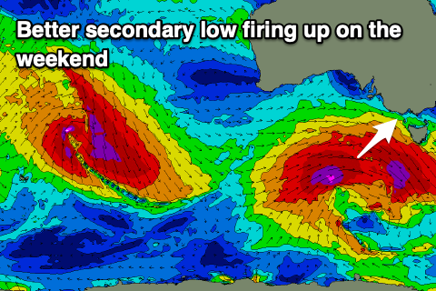
The initial, pre-frontal fetch of gale to severe-gale W/NW winds look great, but the secondary W/SW fetch as the low forms now looks a bit fractured and weaker, with the energy going into a secondary low forming behind it.
 But looking at this first system, and the pre-frontal fetch looks to be the main swell generator now, producing a great pulse from the W/SW on Saturday morning to 3-5ft on the Surf Coast, 6ft+ to the east, with mid-period SW energy softening the easing trend into the afternoon and Sunday morning.
Easing sets from 3ft to occasionally 4ft are due Sunday morning on the Surf Coast, 5ft+ or so to the east. Winds look great Saturday and fresh from the NW all day, stronger Sunday and from the NW again.
Now, looking at the secondary low and we're due to see this fire up south-west of us on Saturday, generating a slow moving fetch of severe-gale W/SW winds through our south-western swell window.
 A larger, long-period SW groundswell is due off this source for Monday, building through the day and peaking to 6ft on the Surf Coast and 8ft+ to the east. The only issue are the local winds with fresh morning W/NW breeze due to swing strong SW into the afternoon as the swell starts to really muscle up.
SW winds look to persist Tuesday as the swell eases, though the Surf Coast should see early W/NW breezes, with easing sets from 4-5ft+ and 6ft to possibly 8ft respectively on both coasts. Cleaner, smaller surf is then due through the rest of the week, but more on this Friday.


Comments
Softening the easing? Is it likely to remain up to 5ft into the arvo on Saturday?
On the sets across the magnets, maybe just, but likely inconsistent and more 4ft.
4ft and inconsistent on the weekend. Great. The usual kooks will be dusting off the 8ft boards, making life a misery for anyone riding a regular shortboard.
Might need to go for a drive.
Looking further afield might not be a good long term option. ; P
At least I'm off the chain this week.
How's old mate on the yellow board at 8:32, dropping in, doesn't pull off, then taking out the bloke he dropped in on and making a run all the way into shore.
Even looks to throw his arms up as if to say 'what did I do wrong' at the 8.53 mark. Can only assume he'd been snaked or dropped in on all day, but gee wiz, bit crook.
Great vid Dx3
Poo man calling 6-8ft winki Sunday isn’t he?
Ha.
You may of defeated the Poo but can you defeat the next challenger, Big Dick Willy (weather)?
Got some preferred winds forecasted….
Depends on how quickly that next trough comes in mid-week. At this stage looks more devil than good.
Massive tidal swings over the next week as well Craig.
No one can defeat me!!
Surely you have a kryptonite? Lack of fibre?
Ive heard police are going to be out patrolling the western port beach carparks over the next few days and into the weekend.
they were out last weekend taking number plates but not sure if anyone got fined.
I suppose you have to weigh up the risk/reward scenario.
Hopefully they fine the cop that lives in McCrae thats surfing WP whenever theres a bit of swell
If you surf westernport you deserve all you get. That place is depresses me.
CS looks sick but with sooo much W it's mostly going straight past. There are a few however that swing ;)
Yep, been a tricky winter to forecast but I feel like I've done fairly well so far.
Mate, you're an absolute gun with your forecasting, no doubt about that. I reckon there were a few randomly refracted 5ft's at the magnets when I took a look but with so much water I kept my wetty dry :)
Nice! And thanks.
Yeah Craig, also agreed. usually read and take your notes and enjoy the banter on this thread . But when it comes to the forecast, you have been pretty spot on with it . Have been lucky to surf a lot lately with your forecast measuring up. not your normal winter swell wise, I would second that. Getting close to the final lap.