Good run of surf from Friday
Victorian Surf Forecast by Craig Brokensha (issued Wednesday 4th August)
Best Days: Late Thursday Surf Coast, Friday and Saturday Surf Coast, Sunday and Monday all regions, Tuesday on the beaches
Features of the Forecast (tl;dr)
- Leftover, weak W/SW swell tomorrow morning with mod-fresh W/NW tending W-W/SW winds
- Late increase in SW groundswell tomorrow, peaking Fri AM with moderate NW tending W/NW winds
- Mod-large SW groundswell for Sat with fresh NW tending W/NW and then W winds (possibly W/SW at periods into the afternoon)
- Slow, easing, mid-period SW swell with light-mod morning N winds, variable NE into the PM
- Easing SW swell Mon with mod-fresh N/NE winds (early early on the Surf Coast), smaller Tue with stronger N winds
- Building W/SW swell energy late next week
Recap
We saw the swell drop back into yesterday, with small 2ft waves on the Surf Coast, 3ft to the east and with clean conditions early on the Mornington Peninsula, decent most of the day on the Surf Coast ahead of a strong W'ly change into the mid-afternoon.
This change kicked up a late increase in windswelly stuff, while this morning came in above what I expected, with the localised fetch of strong winds whipping up 4ft+ surf on the Surf Coast and 6ft waves to the east.
It was low quality as pointed out, with the Surf Coast offering clean, lumpy waves in protected spots. With the swell generating fetch weakening overnight as the low linked to it pushes east, the swell is now on the ease and winds will shift SW into the afternoon.
This week and next (Aug 5 - 13)
The swell generated by a relatively weak mid-latitude low moving across us yesterday afternoon and evening will continue to back off overnight, leaving small, weak 2ft leftovers into tomorrow morning, 3-4ft to the east.
Conditions look favourable for protected spots with a moderate to fresh W/NW tending W/SW-W breeze into the afternoon, but with the weak swell it won't be anything special.
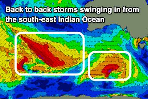
Later into the afternoon new signs of SW groundswell should be see, generated by the first of two frontal systems tracking in from the south-east Indian Ocean.
 This first swell was generated by W/NW gales tracking south-east and then east through our swell window, south-west and south of Western Australia while forming into a low pressure system.
This low is now weakening south-west of Tasmania, with the swell due to arrive late tomorrow and kick to 3ft on the sets across the Surf Coast swell magnets around dark, 4-5ft to the east, ahead of a peak overnight.
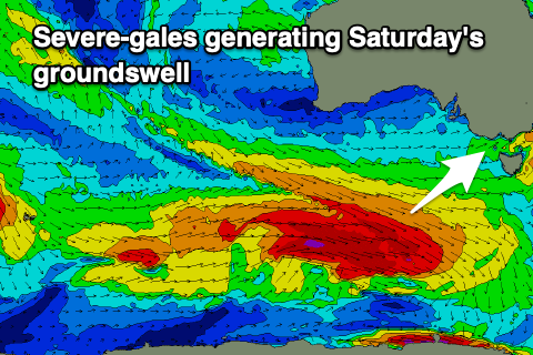
Friday morning should still see 3-4ft sets on the Surf Coast swell magnets, easing through the day with 5-6ft sets to the east. Later in the day some new mid-period swell is due to build ahead of a stronger SW groundswell Saturday which will be produced by a similar frontal progression and low formation to the storm discussed above, but with more strength.
 We'll see a broader and stronger fetch of gale to severe-gale W/NW winds following a similar track, moving on top an active sea state, then consolidating slightly more under the country as a stronger polar low forms. The fetch will remain W-W/NW, aimed a touch away from us, but we'll still see a moderate-large SW groundswell generated, with it due to arrive overnight Friday, peaking Saturday morning.
The Surf Coast should see 4-6ft sets across the swell magnets, 6-8ft to the east, only easing slightly into the late afternoon.
The longevity of the swell will be prolonged with a broad fetch of drawn out W/SW gales forecast behind the strong low, keeping mid-period energy persisting into Sunday to 3-5ft on the Surf Coast and 6ft+ to the east, easing slowly through the day, then backing off from a smaller 3ft and 4-5ft+ on Monday morning respectively.
Looking at the local winds, and protected spots will fair best initially, followed by the beaches on the backside of the swell.
A moderate NW breeze is due Friday morning, shifting W/NW into the afternoon, with Saturday seeing fresher NW tending W/NW and then W winds (possibly W/SW at periods into the afternoon). Sunday should provide lots of options across the state with light, local offshore winds out of the N'th (N/NW Surf Coast and N to the east), tending variable NE into the afternoon.
Monday will play out similar to Sunday but with N/NE winds holding all day east of Melbourne.
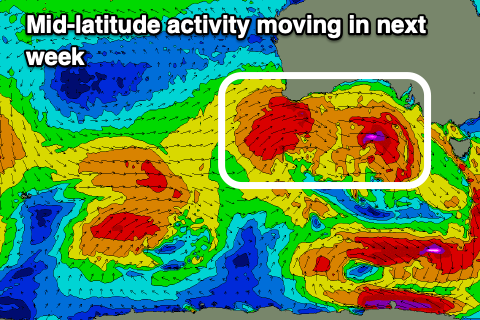
 Into Tuesday the swell will become smaller under a strengthening N'ly breeze ahead of a strong, mid-latitude frontal progression pushing in from the west.
Initially this progression will be less than ideally aimed through our swell window, but it looks to draw up a much stronger polar frontal system behind it mid-late week, bringing another dose of moderate-large W/SW groundswell. More on this in the coming updates.


Comments
:)
Yeww
Yeewww shaka yeewww shaka
Our Sal
Hey Craig, what are your thoughts on a long period swell for Westernport, Good or Bad. I reckon it's bad, too shallow. I might be wrong.
Will the Saturday swell be south enough to fill into Westernport?
Will be inconsistent 1-2ft with 50 odd longboarders per location to share it with
Plus half a dozen Suppers on gutless 1-2 foot. O how I hate Westernport.
Probably going to be in lockdown by Saturday now anyway. FFS
Well called geek strange times indeed, wonder how many are gonna check out with this one
Jeez if your calling Friday onwards a good run you'll be frothing from Sunday the 15 th onwards. Long range forecast looking good
Hmm, not especially..
The lows forming off Antarctica next Wednesday directly between South Africa and Oz look way more intense than yesterday. Both the highs are slighter closer to the equator and angled a bit better compared to yesterday.
Yes, but again, inconsistent, long-range groundswell energy, the W/SW groundswell due late next week from the progression up towards WA is much better.
The stuff from afar is unconsolidated and not overly significant at this stage.
So saying next Sunday onwards is a lot better than what's coming over the coming days is a bit off the mark :)
50-70% chance at this stage the weather man would say
And check out how close that low is to the tip of South Africa next Thursday. That can only intenseiaf the two storms in front of it. The more I look at the satellite forecast the more confident I am actually
Lockdown again just in time for a great weekend of waves. What a blow for most.
Was going to jump on the ferry this weekend with my mid length to drop in on viclocal too :( looks like there might be enough wind for a bay wave mid next week for the truely desperate
That's the spirit!
I'm waxing up my 7'0 right now... so much volume, really lets me get into the waves earlier...
Think I'll do the same. Dedicate the lockdown to midlength surfing.
Is there a end to this or do we just alternate fortnightly between lockdown and slightly less locked down?
A mate of mine lives in London and she's off to Spain & then Greece this weekend...
How fucked has this joint become
Our test as a country will come when/if we get the vaccine rates up to this 70% target they’ve landed on. Will the politicians have the strength to stand by their word and open up, or will they follow the polls and do what’s popular? Lockdowns are popular (not amongst many of us or people you may know, but they are), and until they are not they will continue.
Bugger, I was planning my first return to the water post injury too.
Bummer guys aghh. What a shit show.
What a time to be alive!!!
I will be running the 20km gauntlet twice as fast tomorrow. Just putting out there for all the soft cocks
Wow it actually looks like fucking shit out there
Patience mister poo man. Way better surf to come.
twas bumpy