Slow week, increasing activity from the weekend
Victorian Surf Forecast by Craig Brokensha (issued Monday 12th July)
Best Days: Today on the beaches, tomorrow selected locations, Sunday and Monday Surf Coast
Features of the Forecast (tl;dr)
- Inconsistent W'ly groundswell building today, holding tomorrow, easing Wed
- Light to moderate N/NW winds tomorrow, stronger from the N Wed
- Building, mid-period W/SW swell Sat, peaking Sun with W/NW tending W/SW winds
- Inconsistent SW groundswell Mon with NW winds
Recap
The Mornington Peninsula picked up a touch more size than expected on the weekend, only 1-2ft but surfable for the keen, with tiny surf elsewhere. Today, a very inconsistent W’ly groundswell is on the build, with it pinging on the wave buoys and we should see infrequent 2-3ft sets into the afternoon on the Mornington Peninsula. Winds will strengthen but should hold from the N’th.
This week and weekend (May 13 - 18)
This afternoon’s increase in infrequent W’ly groundswell was generated in our far western swell window, south-west of Western Australia last week. No size or consistency is expected at all with the Surf Coast due to remain tiny as it fills in this afternoon, holds tomorrow, then easing Wednesday.
The Mornington Peninsula may see infrequent 2-3ft sets and winds will be workable through not great with a moderate N/NW breeze due most of tomorrow.
 As the swell eases Wednesday winds will strengthen from the N’th, again creating tricky and less than ideal conditions.
From here there’s nothing significant due through the rest of the week, with the swell bottoming out as winds hold moderate to fresh from the N’th on Thursday and N tending NW on Friday.
This will be due to a slow moving mid-latitude frontal progression moving in from Western Australia sitting too far high through the Bight to generate any size at all. It’ll all be aimed into South Australia.
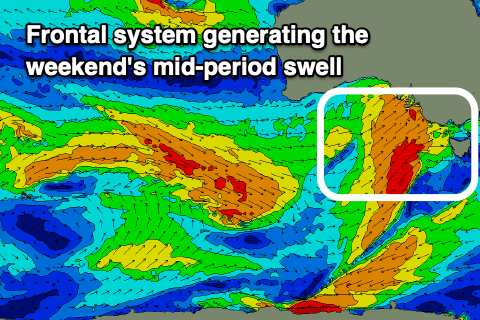
As we move into the end of the week though, a stronger, broader frontal system will project strong to gale-force W/SW winds through the Bight and just south-west of us into Saturday, producing a building, mid-period W/SW swell through Saturday. The front will strengthen on approach, generating a moderate to possibly large sized, W/SW swell, building Saturday afternoon and peaking Sunday.
ECMWF has the front arriving a little later and being a touch weaker while also riding further north, so we’ll side with that at the moment, with the swell building later rather than earlier and at this stage, reaching the 4ft range across the Surf Coast and 6ft+ to the east. Winds will be strengthening from the NW shifting SW with the first front Saturday as the swell builds, W/NW tending W/SW on Sunday.
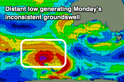
 Unfortunately there’s no backup systems behind this standalone front, meaning we’ll see the size tail off further into Monday. Slowing this easing trend though will be an inconsistent SW groundswell generated by a polar low firing up east of the Heard Island region on Wednesday. This should keep inconsistent 3-4ft sets hitting the Surf Coast, with 6ft sets to the east under a favorable NW offshore.
Longer term we may see some favourable frontal activity firing up south of the country Tuesday/Wednesday, but more on this in the next update.


Comments
Hey Craig not sure if this was mentioned somewhere already but is that second el Nina confirmed? Is this why we are seeing such poor swell and how long will it last if so :'(
Yeah looks to be linked, yeah I mentioned here and commented last night. Only Niña Watch but heading that way.. https://www.swellnet.com/news/swellnet-analysis/2021/06/24/are-we-heading-double-dip-la-nina
This is great. The last thing we need is packs of Melbourne surfers coming to torquay in the middle of flu season