Better swell tomorrow, though not a guarantee
Victorian Surf Forecast by Craig Brokensha (issued Friday 2nd July)
Best Days: Saturday, Sunday Surf Coast, Monday morning Surf Coast, Wednesday, Thursday on the exposed beaches
Features of the Forecast (tl;dr)
- Mid-period W/SW swell late today
- W/SW groundswell early tomorrow, easing in period and tending SW during the day. Fresh to strong N/NW winds
- Easing SW swell Sun with a W/SW windswell for the PM with strong NW tending W/NW winds, easing Mon with moderate W/NW winds
- Mid-period S/SW swell for later Tue, peaking Wed AM with N tending NE winds, easing Thu with N/NE winds
Recap
Tiny waves yesterday morning, with a new, inconsistent, mid-period W'ly swell not really making much of an impact into the afternoon. The Surf Coast kicked to a very slow 1-2ft on the swell magnets, 2-3ft to the east, but this swell has since eased back this morning leaving tiny 1-1.5ft sets on the Surf Coast and 2ft to occasionally 3ft to the east.
This initial swell was never expected to be great, but it looks to have been too west, inconsistent and weak to offer any real size. Later this afternoon our new, reinforcing W/SW swell should provide better surfing options with sets hopefully to 3ft on the Surf Coast magnets and 4-5ft+ sets on the Mornington Peninsula if all goes to plan. Winds will should hold from the N'th, shifting NW towards dark.
This weekend and next week (Jul 3 - 9)
With this morning's inconsistent, mid-period W'ly swell not offering much in the way of size, we look to the reinforcing pulse due later today from a good pre-frontal fetch of W/NW gales under WA on Wednesday.
This should provide inconsistent but better 3ft sets on the Surf Coast magnets late today, with 4-5ft+ waves to the east with those gusty N winds, shifting NW towards dark.
Luckily this reinforcing swell will be replaced by a better aligned and more reliable swell tomorrow, though it's not a given.
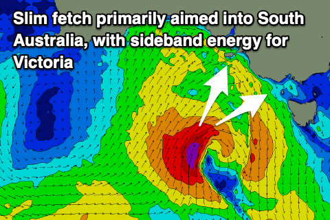
 Our most reliable swells come from broad, drawn out cold fronts, but tomorrow's will come from a tricky mid-latitude low, which sees a more focussed, directional swell owing to the slim fetch of strong winds around it.
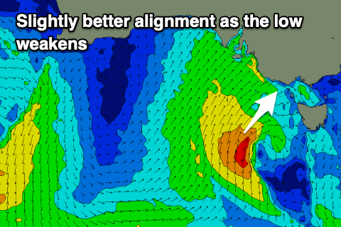
This low has formed and is sitting south of the Bight, with a tight fetch of severe-gale S/SW winds sitting just within our swell window, moving more into our swell window today but as the low weakens and pushes slowly east.
Owing to the location of the low, the swell looks to come in initially from the W/SW, tending SW through tomorrow with the most period early, easing through the day.
Size wise the Surf Coast looks to come in around 4ft on the sets across the swell magnets easing through the day, dropping further Sunday morning from 2-3ft. The Mornington Peninsula should see 5-6ft sets, easing through the day, back to 4ft to occasionally 5ft Sunday morning.
 Winds tomorrow will be fresh to strong but persistent from the N/NW all day tomorrow, favourable most of Sunday and strong NW tending W/NW as the low pushes across us.
The models are showing a pulse of swell for the afternoon but this is localised, from strong W/SW winds pushing through Bass Strait. In reality we'll likely just see weaker, windswelly 2-3ft sets continuing on the Surf Coast into the afternoon, 4-5ft+ to the east, easing from a similar size Monday morning with persistent, moderate W/NW winds.
As the localised, weak W/SW swell eases further into Tuesday, we'll see some mid-period S/SW energy taking its place, persisting into the end of the week.
The source of this run of swell will be a persistent fetch of strong W/SW winds on the polar shelf, south-west of Tasmania from Sunday through Wednesday evening, with the initial stages being strongest.
Varying pulses of mid-period S/SW swell are due through next week, with the best arriving later Tuesday, peaking Wednesday morning. The Surf Coast should offer 3ft+ sets at the swells peak, 4-5ft to the east Wednesday morning and with a N'ly tending NE breeze. The surf will then slowly tail off into the end of the week under favourable N/NE winds for the beaches.
Longer term, as touched on in previous updates, a broad, very slow moving mid-latitude low firing up across Western Australia will put a block across our main swell windows through most of next week, while also generating no meaningful swell itself.
There's still no end to the mid-latitude frontal activity/lows into the middle of the month, though we'll continue to keep an eye on this. Have a great weekend!


Comments
Finally the Surf Coast comes to life. Strong, cold, NW winds grooming long lines of groundswell. Good size as well. More please.
Good to see the swell perform as it could have gone either way.
Went alright in the east too, fun day
Fucken next level crowds today.
Less weekend surf......more weekday surf please Huey.
Stacked lines to the horizon at times today on the Surf Coast. Sight for sore eyes.