Generally favourable winds with fun swell pulses
Victorian Surf Forecast by Craig Brokensha (issued Wednesday 23rd June)
Best Days: Friday ahead of the late change, Saturday and Sunday morning protected spots, beaches Monday and Tuesday
Features of the Forecast (tl;dr)
- Inconsistent SW groundswell for Fri with mod-fresh N/NE winds, shifting N/NW early arvo and the S/SW late
- Mix of swells Sat and Sun with fresh W/NW tending late NW winds Sat, strong NW tending W/NW and then weak S Sun
- Good, mid-period SW swell Mon with N/NE tending NE winds, easing Tue with fresh N/NE winds
Recap
A continuation of good waves on the exposed beaches yesterday, easing from 3-4ft on the Mornington Peninsula, 2-3ft at 13th Beach and 2ft around Torquay.
Today the swell has eased further leaving tiny waves on the Surf Coast and slow 2ft sets to the east with a fresh offshore wind.
This week and next (Jun 24 - Jul 2)
The surf will continue to bottom out into tomorrow, leaving tiny to flat conditions on the coast under a moderate to fresh N/NE breeze.
Into Friday a new, inconsistent SW groundswell is expected across the state and now winds are looking more favourable for a longer period of time ahead of a mid-afternoon change.
The source of the groundswell was a polar low, generating a pre-frontal fetch of severe-gale W/NW winds the last two days, weakening and tending more W. The remnants of this storm is now south of the country, with the swell on the way towards us. It'll be inconsistent but should fill in Friday and peak to 3ft on the Surf Coast with 4-5ft+ sets on the Mornington Peninsula.
The slow moving mid-latitude low to our west will stall a touch longer than forecast Monday, resulting in moderate to fresh N/NE winds Friday morning, tending more N/NW early afternoon ahead of a late S/SW change.
 This should provide plenty of opportunity for a wave across both coasts.
Saturday will see winds revert back to the W/NW still as another cold front approaches from the west, likely tending NW towards dark.
Friday's swell will ease temporarily into Saturday morning, while a reinforcing S/SW groundswell looks to steady the easing trend through the afternoon. This will be generated by another polar front firing up late in our swell window this evening. A poorly aimed fetch of pre-frontal W/NW gales will be closely followed by post-frontal W/SW winds, with 2-3ft surf due most of the day Saturday on the Surf Coast, 4ft+ to the east.
Sunday looks to hold a similar size as we sit between swell pulses, with the next noticeable increase due into Monday. Winds on Sunday will be strong at dawn from the NW, tending W/NW ahead of a weak S'ly change into the afternoon.
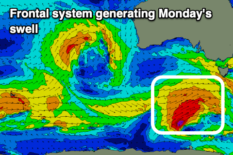
Looking at Monday's swell and we'll see a polar front project a fetch of W/SW gales through our south-western and then southern swell window from Friday through Saturday, moving under Tasmania on Sunday.
The swell will be mid-period in nature but offer some fun size with 3-4ft waves on the Surf Coast, 5-6ft to the east and with a light N/NE morning breeze as a high moves in behind Sundays change. Winds should hold out of the NE into the afternoon as the swell starts to slowly ease, smaller Tuesday with a fresher N/NE breeze.
Following this swell we'll see the storm track focus up towards Western Australia temporarily but this isn't ideal for us with the swells coming in west and without any major size. We may see some mid-period surf from the remnants of this progression as it moves through the Bight mid-late week, but we'll keep a close eye on this.
Beyond that, as discussed in this article I penned yesterday the outlook remains void of any major Southern Ocean frontal activity into the longer term. I'll continue to provide updates on any change in the coming weeks.


Comments
https://www.9news.com.au/national/close-shave-with-shark-for-body-boarde...