Easing surf, with a new swell late week
Victorian Surf Forecast by Craig Brokensha (issued Monday 21st June)
Best Days: Exposed beaches tomorrow, Friday selected spots workign the winds, Saturday protected spots
Features of the Forecast (tl;dr)
- Easing W/SW groundswell over the coming days with slowly increasing N/NE winds
- Inconsistent SW groundswell for Fri with early N, tending NW and then W winds
- Easing SW swell Sat ahead of a new, reinforcing S/SW groundswell for the PM with strengthening W/NW tending NW winds
- Mix of swells Sun with a developing S/SW change, cleaner Mon with more variable winds
Recap
Average surf Saturday with a lingering onshore breeze and easing swell fro Friday, cleaner yesterday morning with a temporary low point in swell. The beaches were the pick and a new W/SW groundswell provided fun options as it filled in through the day.
Today the swell is hanging in at 2-3ft on the Surf Coast and 3-5ft to the east under favourable winds, but we'll see the size drop through the day as winds tend NE.
This week and weekend (Jun 22 - 27)
As touched on the last couple of updates, we'll see the surf easing from this morning following the W/SW groundswell pulses, bottoming out into the middle of the week/Thursday.
Conditions will be favourable for the exposed beaches though as a mid-latitude low stalls across Western Australia, directing persisting N/NE winds across us.
Tomorrow will see moderate N/NE winds, possibly freshening a touch through the day and easing 3-4ft sets on the Mornington Peninsula, 2ft on the Surf Coast.
Fresh to strong N/NE winds will kick in Wednesday but size wise, the Surf Coast will be tiny and the Mornington Peninsula fading from an inconsistent 2ft or so. Thursday will be clean again with a fresh N/NE breeze but with no real swell.
As the week progresses we'll see the mid-latitude low moving slowly towards us, but breaking down across South Australia. The remnants are due to move across us Friday, swinging winds from N'th at dawn, to NW and then W'ly into the afternoon.
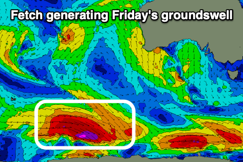
 This will be with a new, inconsistent SW groundswell, generated by a slim fetch of severe-gale W'ly winds moving along the polar shelf over the coming days. The slim nature of the fetch isn't ideal and as a result, it'll limit the size expected across our region.
Inconsistent sets to 3ft are due on the Surf Coast, 4-5ft+ or so to the east (possible rare bigger one) and with those shifting winds.
The swell will ease Saturday morning, though a reinforcing, similar sized (to Friday) S/SW groundswell is due into the afternoon, generated by a late forming polar, south-west of us Thursday.
Gusty W/NW tending NW winds ahead of an approaching cold front looks to favour protected spots, swinging S/SW on Sunday in the wake of the front. Some moderate sized, mid-period swell is likely in the wake of the front Sunday afternoon and Monday morning and with what looks to be improving winds as a high slides in from the west.
Longer term the westerly storm track will fire up and into Western Australia from the weekend, but this isn't ideal for us, with the swells being poorly aimed and coming in from the west.
It looks like winds will persist out of the northern quadrant though as a strong high sits just to our south-east, but more on this in the coming updates.

