Good winter run on the beaches
Victorian Surf Forecast by Craig Brokensha (issued Friday 18th June)
Best Days: The beaches from Sunday through all of next week (Thursday not included)
Features of the Forecast (tl;dr)
- Easing, inconsistent W/SW groundswell tomorrow with moderate S/SE winds
- Inconsistent W/SW groundswell for Sun PM, easing Mon AM with NE tending SE winds Sun, N/NE tending E/NE on Mon
- Further drop in size Tue and Wed with favourable N/NE winds, fresher NE Wed
- Inconsistent SW groundswell Fri with mod-fresh NE winds
Recap
Clean conditions across the Surf Coast yesterday's with inconsistent 2ft sets for the patient, decent early across the Mornington Peninsula before deteriorating through the day.
Today we've got an inconsistent, new W/SW groundswell on the build but early W'ly winds have since shifted onshore from the S/SW and are increasing, creating deteriorating conditions.
This weekend and next week (Jun 19 - 25)
Today's inconsistent though building W/SW groundswell should reach 4-5ft+ across the Surf Coast magnets this afternoon and 6-8ft on the Mornington Peninsula but it's all academic with the poor, onshore winds.
The swell will ease through tomorrow, back from the 4ft range on the Surf Coast and 6ft+ to the east. A strong Tasman Low which has formed to our east will continue to bring onshore winds tomorrow, moderate in strength though and out of the S/SE, persisting most of the day.
From Sunday we'll see conditions improve as a high moves in from the west, but it'll be very slow moving owing to a mid-latitude low firing up across the southern region of Western Australia, stalling west of us most of next week.
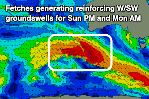
 Winds feeding in from the north-eastern quadrant will favour the beaches as we see some initial reinforcing groundswell pulses Sunday and Monday morning, tailing off into the middle of the week.
The first pulse of reinforcing groundswell will arrive mid-late morning Sunday, generated by a patchy though good fetch of severe-gale to storm-force W/NW-W winds around a low that formed south-west of Western Australia mid-week.
Size wise, the Surf Coast looks to be 3ft on the sets across the swell magnets, 4-5ft to the east early, ahead of the new swell which should build to 4ft on the sets across the swell magnets west of Melbourne and 6ft to the east.
A similar size, reinforcing pulse of W/SW groundswell is due Monday from trailing severe-gale W/NW winds stretching out under the country today and early tomorrow.
Expect 4ft sets on the Surf Coast magnets Monday morning and 6ft sets to the east Monday morning, then easing into the afternoon and dropping further from 2-3ft and 4-5ft respectively Tuesday.
Coming back to the local winds and a light E/NE-NE breeze is due Sunday morning, possibly tending N-N/NW for a period on the Surf Coast, back to the SE and moderate to fresh into the afternoon.
 Monday will see more favourable N/NE winds, shifting E/NE-NE into the afternoon and then N/NE tending NE winds on Tuesday. Fresher NE winds will kick in Wednesday as the swell fades and bottoms out.
Longer term, a small, tight polar low firing up east of the Heard Island region Sunday evening looks to generate an inconsistent SW groundswell for Friday. A slim fetch of severe-gale to storm-force winds should produce fun sized waves across both coasts, arriving overnight Thursday and peaking Friday to 3ft on the Surf Coast and 4-5ft+ to the east. Winds will remain offshore from the NE as the mid-latitude low hangs west of us, more N'ly Saturday as the swell eases and then NW from Sunday but with no swell.
Longer term there's a bit more action expected to fire up towards Western Australia late in the month, but this will be in our medium-range western swell window. In the meantime make the most of fun winter waves on the beaches. Have a great weekend!


Comments
I accept
Onya Craig. Looking forward to getting a fresh stick of wax under the feet. See you in the green room.
what r we talking here sex wax or mrs palmers...
If you're really 69 you might have that ol stash of Ampol but doubt the freshness & hard as concrete if I remember rightly!