Weak, mixed week, better into next week
Victorian Surf Forecast by Craig Brokensha (issued Monday 31st May)
Best Days: Beaches tomorrow and Wednesday afternoon, Thursday selected spots, Saturday on the Surf Coast, Sunday afternoon through next week on the Surf Coast
Features of the Forecast (tl;dr)
- Easing W'ly groundswell tomorrow with freshening N/NE winds
- Inconsistent SW groundswell building Wed PM, easing Thu with gusty N/NE winds on the former, N/NW tending W/NW ahead of a late SW change on the latter
- Mix of swells for Fri with strong SW tending S/SW winds, easing Sat with fresh NW tending N/NW winds
- New mid-period W/SW swell for Sun PM with fresh NW winds
Recap
Average surf Saturday with an easing mid-period swell from Friday with lingering onshore winds, cleaner Sunday morning on the beaches but back to 1-2ft on the Surf Coast and better to the east with 2-3ft sets.
A new, infrequent W'ly groundswell built into the afternoon as winds remained favourable, fun this morning with the swell now easing from 3-4ft on the Mornington Peninsula, 2ft on sets across the Surf Coast.
This week and weekend (Jun 1 - 6)
Our current swell will continue to ease into tomorrow and Wednesday morning, coming in tiny across the Surf Coast tomorrow and fading from an inconsistent 2-3ft on the exposed beaches east of Melbourne.
Conditions will be great with a freshening N/NE breeze, holding all day tomorrow, similar Wednesday morning but the surf will be tiny even on the Mornington Peninsula.
A new, inconsistent, mid-period SW swell for the afternoon is on track, generated by a short-lived and not overly strong polar front over the weekend, south-southwest of Western Australia. This front is now weakening while moving east with an inconsistent swell due to build Wednesday afternoon, reaching 2ft+ on the Surf Coast magnets, 3-4ft+ to the east, easing from the same size Thursday morning.
Expect long waits for sets and Wednesday afternoon looks the pick with the N/NE breeze, N/NW tending W/NW ahead of a late, shallow change Thursday. There's an outside chance of early light N winds on the Mornington Peninsula but we'll review this Wednesday.
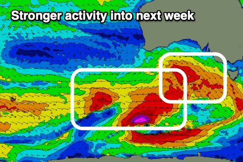
 As touched on the last couple of updates, the outlook is a bit more active into the end of the week and weekend but it'll be from less favourable, east-southeast tracking fronts through our swell window ahead of some better aligned storms next week.
An initial tight polar low firing up in a similar position to the weekend's polar front will generating a small, inconsistent SW groundswell for Friday, but this will be mixed with mid-period W/SW-SW energy from weak, pre-frontal and post-frontal W/NW-W/SW fetches moving under the country late week.
Size wise, the models are mixing the swells and over-forecasting the size, so expect surf to 2-3ft on the Surf Coast, 4-5ft to the east. Winds will be poor in any case as a cold front brings a strong SW change just before dawn Friday, shifting S/SW through the day.
This change will add some additional, close-range S/SW swell to the mix on Saturday morning as winds swing back to the NW tending N/NW with another approaching front.
 Size wise, the Surf Coast should ease back from the 3ft range, 4-6ft to the east.
Sunday looks to start slow but the approaching cold front will bring pre-frontal W/NW gales and a building W/SW swell through the afternoon, with some better SW swell to follow.
Size wise this looks to be more around 3ft+ on the Surf Coast, 5-6ft to the east as winds hold from the NW, with larger, windier surf likely to develop through the week next week.
Timing wise we're probably looking at 4-6ft waves on the Surf Coast with winds out of the western quadrant, but more on this in the coming updates.


Comments
so we're not really missing much
Nope.