Fading surf, lots of action from later week
Victoria Forecast by Craig Brokensha (issued Monday 2nd November)
Best Days: Today on the exposed beaches, Friday morning protected spots, possibly Sunday morning, Monday morning
Recap
Poor surf across all locations most of the weekend, but the Mornington Peninsula and Phillip Island offered a window of lighter winds yesterday morning and OK waves for the desperate.
This morning conditions are on the improve across the exposed beaches with a small, easing mid-period S/SW swell from 3ft, small and to 1-2ft on the Surf Coast.

Well worth a surf
This week and weekend (Nov 3 - 8)
The coming couple of days aren't surf days with this morning's swell due to fade and bottom out through tomorrow and Wednesday morning. There'll be tiny peelers across the exposed beaches for beginners tomorrow with a moderate to fresh N/NE wind, flat Wednesday morning as winds shift NW ahead of a late morning SW change as a surface trough moves through, strong into the afternoon.
Unfortunately this change will leave strong, but slowly abating S/SW winds across the state on Thursday as our new, inconsistent SW groundswell fills in.
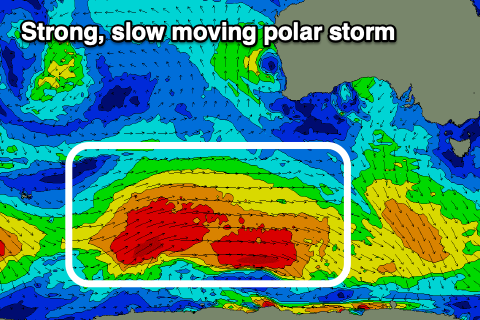
 This swell started to be generated through our far swell window, around the Heard Island region on the weekend with a broad polar low generating a slow moving fetch of W/SW gales.
The low is currently on the polar shelf, south-west of WA and continuing to generate W/SW gales, with it due to weaken very slowly this evening will moving further east.
A secondary weaker polar front is now forecast to move in behind the low, generating a fetch of strong W'ly winds and reinforcing SW swell for Friday.
Looking at the expected arrival time and size, we should see the inconsistent, long-period energy arriving overnight Wednesday with the swell building Thursday and reaching 4ft on the Surf Coast swell magnets through the day, 6ft+ to the east but with those onshore winds.
Friday looks better in protected spots as another approaching front tips winds back to the W/NW across the Surf Coast, though remaining from the W/SW to the east. The afternoon will see fresher S/SW-SW winds and size wise we should see the Surf Coast ease a touch back to 3-4ft Friday morning and 5-6ft to the east.
Our reinforcing SW swell from the secondary front firing up behind the low is due later Friday but should peak Saturday morning, maintaining 3-4ft sets on the Surf Coast and 5-6ft waves to the east.
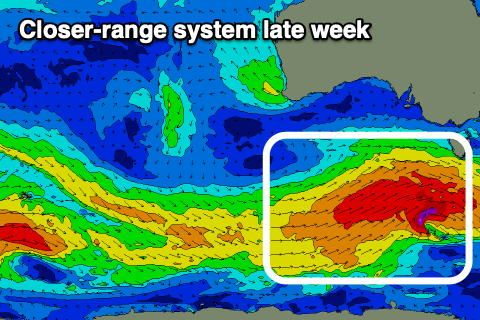
 Into the afternoon we've got a stronger, third pulse of SW groundswell on the cards, as a stronger front develops under the country Thursday, projecting W/SW gales through our south-western and then southern swell windows through until Friday evening.
This swell should produce bigger 4ft+ surf across the Surf Coast, 6ft+ to the east, slowly easing from a similar size Sunday morning.
The only issue again look to be the local winds with the swell generating front moving through Friday evening, followed by a high, bringing strong S/SW tending S winds on Saturday, possibly swinging E/SE Sunday morning, but more on this in Wednesday's update.
At this stage Monday looks cleanest as the swell eases just in time for restrictions to ease further, but check back here Wednesday for confirmation.


Comments
First forecast notes that I’ve read in a long time - it’s been too hard to read them of late
Cant wait for next week.
Bring the goods Craig & Huey -
A week of options to spread us out.
A cupla fun little runners this morning in between minutes of, well, nothing. Still worth it with less than a handful where I was.
Gunna try and squeeze out every drop between now and 9/11 cause it is gunna be ugly from all angles from then on.
No doubt there will be a few strung out surfers worshipping the sand and saltwater from 9/11.
Gunna already packed with 40 to 50 at first carpark today and very average banks
extremely average on the whole stretch (and I'm not just saying that to keep the crowds down!), a lot of driving and not much surfing today
If everyone minds their manners it'll be fine.