Generally poor, windy week
Victoria Forecast by Craig Brokensha (issued Monday 26th October)
Best Days: Protected spots keen surfers tomorrow and Wednesday, Thursday from mid-morning exposed beaches for the keen
Recap
Poor conditions all weekend with fresh to strong onshore winds out of the SW Saturday with a building swell, S/SE on Sunday as the swell peaked
Today the groundswell is on the ease as a moderate sized and stormy SE windswell develops along with strong E/SE winds.
This week and weekend (Oct 27 – Nov 1)
Well it looks like I've returned to an average week of surf across the Victorian region, with only a couple locations set to handle the winds over the coming days.
An intense, wet surface trough that's deepened off the southern NSW coast is squeezing a strong high to our south-west, bringing strong and persistent E-E/SE winds through Bass Strait today, tomorrow, easing off slightly Wednesday as the trough weakens and the high moves slowly east.
We'll see moderate sized + levels of E/SE-SE windswell across the Surf Coast and to a lesser extent locations east of Melbourne, building tomorrow ahead of a peak overnight, easing Wednesday.
Strong and increasing E-E/SE winds will create generally poor conditions tomorrow except for a couple of protected spots with building surf to a stormy 4-5ft on the Surf Coast, 3ft+ or so on the Mornington Peninsula all day with the easing mid-period swell and building windswell.
Winds should ease a touch Wednesday but remain fresh to strong from the E-E/SE as the SE windswell eases from 4ft or so on the Surf Coast, 2-3ft to the east.
We'll see winds swing back offshore during Thursday creating improving conditions with a dawn E'ly, swinging E/NE and then N/NE late morning ahead of sea breezes.
 The surf will be at a low point though with a fading SE windswell and very inconsistent long-period W/SW groundswell slowly building into the afternoon.
By the time the groundswell reaches any real size on the Mornington Peninsula, sea breezes are likely to set in.
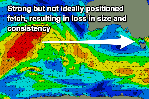
This groundswell, which is due to peak Friday has been generated by a strong, broad and slow moving frontal progression that developed between Heard Island and Western Australia.
The progression formed a little too far north in latitude than ideal, resulting in very inconsistent and small surf across the Surf Coast, a bit better on the Mornington Peninsula, but the local winds look to revert back to the SE-S/SE on Friday as a trough moves in Thursday evening.
This will create average to poor conditions with the Surf Coast offering inconsistent 2ft to possibly 3ft sets on the magnets, 4-5ft to the east on the biggest sets.
Unfortunately the trough will deepen into a low to our north-east while another strong high moves in from the south-west, resulting in strong and persistent S/SE winds Saturday, possibly lighter Sunday but with the easing inconsistent W/SW groundswell and no additional energy to back it up.
Into next week, we'll finally see the pattern break down, with a good looking Southern Ocean frontal progression forecast to push through, bringing winds out of the western quadrant along with a building W/SW groundswell that's likely to peak later week.
This will be linked to a strengthening though not overly significant node of the Long Wave Trough moving in from the west, but the models diverge on the strength and timing so more on this Wednesday.


Comments
Forecast for Monday November 9?!?!
Bring it home Craigos, bring it home
There is no medical reason why someone cannot drive 26ks to the surf or play golf but can drive 24ks to jump in a pool with 30 people or sit in the park with 9 other people - no proportionate medical reason and that is why almost everyone is ignoring these inconsistent and poorly thought through restrictions !!!
So true
Some Easterly junk about today