Funky though fun end to the week, quality waves into next week
Victoria Forecast by Craig Brokensha (issued Wednesday 7th October)
Best Days: Thursday, Friday afternoon Surf Coast for the keen, Saturday morning, Monday morning, Tuesday morning, Wednesday morning
Recap
Terrible conditions across all locations yesterday with a strong onshore wind and building S/SW swell, better this morning though solid on the beaches to the east and to 4-6ft, with surf around 4ft on the Surf Coast. Lighter easterly winds are creating improving conditions on the beaches.
We'll see the S/SW swell easing through the day as winds remain light ahead of late afternoon SE sea breezes.
This week and weekend (Oct 8 - 11)
Looking at tomorrow and we've got a dynamic day of weather and winds as a moisture laden mid-latitude low drifts south-east across us, bringing rain and gusty NE tending strong NW winds. This change in direction looks to occur late morning and we'll be seeing a mix of easing S/SW swell and small SE windswell from strong E winds through Bass Strait.
The Surf Coast should ease from a peaky 2-3ft, with 4ft sets to the east.
On the backside of the low, the windswell pegged for Friday looks more mid-period energy with a better fetch of broader and stronger W/SW winds due to be generated through our swell window Friday.
The swell looks tiny early, building rapidly through the day and reaching 3ft+ on the Surf Coast magnets into the afternoon and 4-6ft to the east. Winds should hold out of the W/NW through the morning, shifting W-W/SW into the afternoon as the swell builds.
We're then expected to see the mid-period energy ease on Saturday as a new, long-period W/SW groundswell takes its place.
This initial, long-range swell won't be especially sizey or consistent with it generated in our far swell window and a little too north than ideal. As a result inconsistent sets to 2-3ft are most likely on the Surf Coast magnets, 4-5ft to the east but with more favourable N/NW winds in the morning.
A fresh SW change is due early afternoon as a weak trough moves through, reverting back to the W/NW on Sunday morning. The swell looks to lose a touch of size and consistency Sunday and it'll be on the small side across the Surf Coast.
 Next week onwards (Oct 12 onwards)
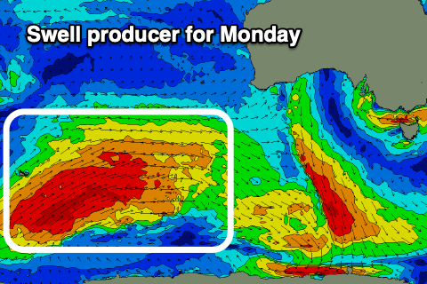
Our stronger and larger W/SW groundswell for Monday is on track, with a more significant, broader and closer projecting fetch of W/SW gales due to move through our swell window. The storm is currently forming in the Heard Island region and will project on the back of the active sea state generated by the front linked to Saturday's swell.
It'll weaken south-west of WA early Friday, with the swell travelling towards us on the weekend, arriving overnight Sunday and peaking Monday. The Surf Coast should see inconsistent 4-5ft sets on the magnets with 6-8ft sets on the Mornington Peninsula with what looks to be variable morning NW winds ahead of SE sea breezes.
 The swell is due to ease temporarily into Tuesday morning with N/NE winds, favouring the beaches but sets are likely still to be around 4-6ft, 3ft+ on the Surf Coast.
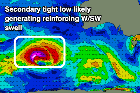
A follow up W/SW groundswell is on the cards for the afternoon though, generated by a strong, tight low forming on the back of the broad polar front. The models diverge a little on the strength of this system but we'll likely see a kick in size similar to that of Monday's swell (if not slightly bigger) and with more period. Winds look to persist out of the N/NE into Wednesday as it starts to ease, but more on all of this in Friday's update.


Comments
finally some decent energy on the way
Is there a way to check the wind in the middle of bass straight
Yeah, try this.. http://www.bom.gov.au/marine/wind.shtml?unit=p0&location=vic&tz=AEDT
East of the Prom, yes.
Hogan Island: http://www.bom.gov.au/products/IDV60801/IDV60801.94949.shtml
Kingfish B: http://www.bom.gov.au/products/IDV60801/IDV60801.55039.shtml
West of the Prom, only King Island.
http://www.bom.gov.au/products/IDT60801/IDT60801.94850.shtml
thanks crew the live obvs was what I was after
rather excited to see a proper ESE windswell met with offshore winds tomorrow, cant remember the last time the SC had both simultaneously
Yeah, love similar setups on the East Coast, the beaches will be really fun.
Lorne for the win this morning (again!). First in grayscale:

Then in colour:

Very jealous of what I saw on the cams this morning....13th resembling punchy North Coast beachies.
Would've been a great novelty day.
It was Stok. Got some crackers early!
Sick - for me this sort of day would be worth more than say a traditional Southern Ocean 3-4ft SW swell WNW wind combo...in terms off froth levels.
Yeah, coming from surfing straight, Southern Ocean groundswells to then lay your eye on a peaky, skate park looking beachy is pure bliss for southerners.
Agreed!
Luckily we have a few beachies here with a good outer reef/bank which mimics this too a degree....but yeah generally jealous of the kms upon kms of open, peaky beachies on the EC.
Give me 3ft grinders in boardies over 5ft walls in wetties any day!
Still, it's funny to chat to some lifelong EC surfers and they generally speak with envy when they think of the long period, powerful beachies and reefs we get here....grass is always greener to a degree I guess.
13th ey. Musta sailed on past us. Fucking gutless on the Southern tip here.
Yeah pretty average morning compared to what could of been.
It was never going to be Straddie but was hoping for a bit more peaky-ness
Can’t remember year let alone month but could narrow it down by what house i was, thinking 15/16, when we got nearly a full day of a proper peaky swell. Wouldn’t be a stretch to say there were some 6fters. Anyways, anyone you spoke too had a absolute cracker! Everyone thought they we’re at the spot but it was the whole fucking coast going bananas. Where the fuck are those days hiding...?
This day happen to be a Sunday? I remember it pretty clearly
Was a Sunday. Arrived a bit late to the party because of the party.
yeh it did, other end gutless (but still a bit of fun) too. Its like the Surf Coast with westerly swells I guess
I remember that day well tubba and NB. Yeah it was a weekend. Straddie-like peaks as far as you could see.
Juc was fucking cracking mid morning, most stoked I’ve seen a crowded lineup in a very long time.. swell will be all but gone by dark tonight ‘‘twas good while it was On for a couple hours
It was still good in the arvo.
I was standing at the top of the stairs at signies this morning and there was about 40 odd peaks in view all up and down the beach with waves breaking left and right like cheese coming out of a grater. Happy east days