Fun tomorrow, increasing swell from late week
Victoria Forecast by Craig Brokensha (issued Monday 28th September)
Best Days: Exposed beaches tomorrow, Surf Coast later Thursday, Friday, Saturday
Recap
Average to poor conditions all weekend with a mix of windswell and mid-period S/SW energy in the wake of Friday's change and a polar front pushing up and towards us Saturday.
Today we've got cleaner conditions as winds has eased off and tended more variable along with fun levels of mid-period S/SW swell to 3ft on the Surf Coast and 4-5ft to the east.
This week and weekend (Sep 28 – Oct 4)
Today's S/SW swell, which arrived yesterday afternoon, was generated by a broad polar front projecting up through our swell window on Saturday, with a drop in size expected this afternoon as winds shift more S/SE-SE late.
One more reinforcing pulse of S/SW swell is due for tomorrow as winds shift N/NE, providing fun waves across the state's beaches. This was generated by a late forming polar front on the tail of Saturday's system, but more zonal in alignment. Therefore it'll have more south in it and should provide 2ft+ waves across the Surf Coast tomorrow morning, 3ft+ to the east before easing into the afternoon and becoming small to tiny Wednesday.
Winds should hold most of it not all of tomorrow out of the N/NE-NE across the Mornington Peninsula and Surf Coast, possibly swinging SE across Phillip Island.
Come Wednesday morning an early fresh N'ly is due, shifting NW through the day but the exposed beaches will be lucky to be 1-2ft, tiny on the Surf Coast.
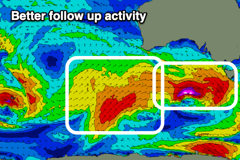
We then look at the mid-latitude and polar frontal activity moving in and under the country this week, generating pulses of new W/SW swell.
 Initially the mid-latitude activity looks weak and not overly well constructed, with a weak low producing a fetch of strong to near gale-force W/SW winds right through our western swell window Tuesday afternoon/evening and Wednesday, dipping south-east into Thursday.
A small, mid-period W/SW swell should be seen from this source later Thursday but only yo 2ft+ on the Surf Coast and 4ft or so on the sets to the east. The morning will be tiny and a W/NW-NW breeze will favour the Surf Coast.
A secondary and stronger front moving in Thursday will generate pre-frontal W/NW gales in our western swell window, producing a better pulse of W/SW groundswell later Friday and Saturday morning.
Size wise, the morning on Friday looks similar to later Thursday and on the small side, with later Friday seeing better sets hitting 3ft+ and 5-6ft respectively on the Surf Coast and Mornington Peninsula.
 Winds look to remain favourable as another front approaches from the west, bringing fresh N/NW breezes that may even tend more N'ly into the afternoon across the Mornington Peninsula.
Now, following Thursday/Friday's front a drawn out and more southerly positioned frontal system is forecast to generate a healthy fetch of strong to gale-force W/SW winds, producing a swell from a touch better direction.
This is due Sunday, but before this we'll likely see the state holding a similar size to Friday on Saturday with stronger N'ly winds as a deepening inland trough moves slowly in from South Australia.
As the trough drifts east we'll see it unfortunately bring an onshore change Sunday with the new W/SW groundswell, creating bumpy 3-4ft sets on the Surf Coast, 6ft to the east.
Following this we'll see no decent groundswell and just locally generated and poor windswell associated with the trough likely forming into a low early next week, but more on this Wednesday.


Comments
Yo, Craig! There's actually some nice underlying mid-period swell out there today.

Yep, from Saturday's front. Looks fun.