Tricky and slow week with less than ideal swells but good winds
Victoria Forecast by Craig Brokensha (issued Monday 25th May)
Best Days: Surf Coast Saturday, both coasts Monday, beaches Tuesday
Recap
Workable winds and conditions across the Surf Coast Saturday morning though Friday's large S/SW groundswell eased back quite significantly, dropping from 4ft or so, with bumpy 4-6ft sets to the east.
Yesterday was poor across all locations with fresh S'ly winds and a bit less swell, though the easing trend was arrested into the afternoon with the arrival of a new SW groundswell.
This groundswell has started to ease into this morning from 2-3ft on the Surf Coast and 4-5ft+ to the east with lighter winds out of the east, favouring the beaches.
This week and weekend (May 26 - 31)
The coming week and weekend are tricky with distant and inconsistent swells being mixed up by the models so try and ignore the graphs and follow the trends below.
The next two days look fun on the beaches though with offshore winds and smaller swells.
We'll see the swell throttle back more into tomorrow with today's SW groundswell on the ease. Sets to 3-4ft are due on the Mornington Peninsula, 2ft on the Surf Coast magnets, smaller through the day. Moderate to fresh NE winds will favour the beaches, (possibly E/NE at dawn), though into the afternoon we may see winds shift N/NW for a period before going back lighter NE.
 A very inconsistent long-period background swell is likely to maintain slow 3ft sets on Wednesday, 1-1.5ft on the Surf Coast with persistent offshore N/NE winds.
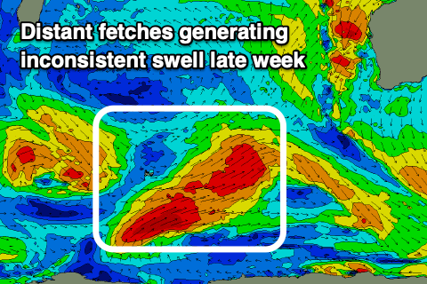
Looking at Thursday and the models are showing a kick in size for the morning, but this is being over-represented with it being generated north of our swell window, just off the WA South Coast (right).
Small to tiny surf is expected to continue ahead of late increase in stronger and but still very inconsistent SW groundswell, peaking Friday,
 This swell, discussed late last week has been generated by very distant but strong back to back polar storms west, south and east of the Heard Island region over the weekend. Inconsistent sets to 3-5ft should be seen on the Mornington Peninsula later Thursday and all day Friday, likely not topping 2ft on the Surf Coast, with the models again incorrectly combining swells.
Winds on Thursday look average (with the lack of swell) fresh NW tending lighter W/NW, but Friday is the day for the beaches with N tending N/NE winds, holding all day.
The swell will drop into Saturday morning with stronger N-N/NE winds, but come the afternoon another tricky pulse of new W/SW groundswell is due. The source is a tight and strong but east-southeast tracking low from under WA, pushing just through our western swell window.
A tight fetch of severe-gale to storm-force W/NW winds should kick up a late afternoon increase in size to 2ft to maybe on the Surf Coast and 4-5ft to the east (we'll confirm Wednesday). Those strong N-N/NE winds will create tricky conditions but there'll be options.
This strengthening northerly will be linked to a strong mid-latitude front moving in from the west, attached to a stronger polar low and behind this we may see a fun new SW groundswell early next week, with greater potential to follow. More on this Wednesday though.


Comments
Craig. What gives with the Woolamai Cam? It seems to have a permanent Fog and visibility has been poor for ages.
Been meaning to get down and install a permenant cleaning system, along with a major camera upgrade too (COVID-19 restrictions means we can't get down). Though, TBH I'm unsure why this location suffers more than Portsea and 13th (same kind of setup and exposure).
Its all good mate, there is much more important things for you to be concentrated on.
I can understand the peak but never seen the significant that high!?
Only really see a high peak for forerunners?
Yeah, shows that the existing swell energy is so weak, hence picking up that signal.
I've seen it around 20s+ or though before.