Lots of swell, mostly going to waste
Victoria Forecast by Craig Brokensha (issued Friday 20th March)
Best Days: Tomorrow from mid-morning, protected spots Sunday PM, keen surfers Tuesday through Thursday
Recap
A touch more swell than expected lingering into yesterday, 1-1.5ft on the Surf Coast and 2ft to occasionally 3ft on the Mornington Peninsula with clean conditions across most spots most of the day.
This morning the swell has eased back a touch from yesterday with clean conditions on the Surf Coast, bumpy and windswelly to the west. Our new S/SW groundswell has hit Cape Sorell but the arrival and increase in size across our coast will be as winds shift W/SW early afternoon and SW into the evening.
This weekend and next week (Mar 21 – 27)
This afternoon’s building S/SW groundswell is on track to peak overnight, early tomorrow morning with sets to 4ft across the Surf Coast swell magnets and 6ft or so on the Mornington Peninsula. Unfortunately our possible window of early W'ly winds on the Surf Coast looks a very low chance now.
We're instead expected moderate onshore S/SW winds, easing though and tending light S'ly through the morning so there should be fun waves across selected spots from mid-morning as the swell slowly eases.
 Our secondary stronger and larger SW groundswell for Sunday is on track, but so are the onshore winds.
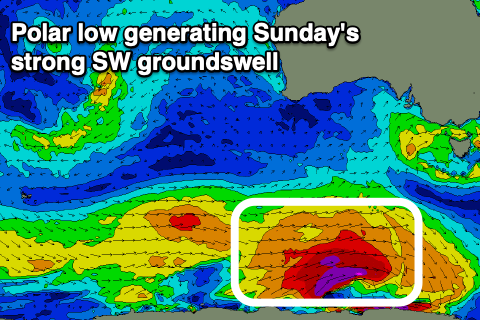
An intense polar low has formed south of WA with a fetch of severe-gale to storm-force W/SW winds being projected through our south-western and then southern swell window today.
We'll see this new long-period and strong S/SW groundswell building through Sunday and reaching 5-6ft on the Surf Coast swell magnets, with 8ft sets to the east, but apart for a very short-lived W/NW breeze likely just before dawn, winds will shift strong SW, creating poor conditions.
As touched on in the last few updates, winds will continue to be an issue across the state most of next week as the node of the Long Wave Trough bringing all the swell continues east, with a strong high moving in behind it.
We'll see fresh and gusty S/SW tending S/SW winds on Monday as Sunday's groundswell eases.
Weaker but lingering S/SE winds are due on Tuesday as a new pulse of moderate sized S/SW groundswell fills in. This will be generated by a weaker but still nice looking polar fetch of strong to gale-force W/SW winds over the weekend.
A kick in size back to 4ft on the sets is due on the Surf Coast magnets, 6ft to the east, dropping temporarily Wednesday morning as winds shift back to the S/SW.
A new SW swell could be seen Wednesday afternoon, generated by a strengthening low dipping east-southeast under the country, again to 3-4ft and 5-6ft respectively, with Thursday seeing an easing trend with hopefully lighter S/SE winds.
From later week and into next weekend we're likely to see cleaner conditions.. but the swell will bottom out at the same time. More on this Monday. Have a great weekend!


Comments
Putrid
Hi Craig, wondering about the larger swell on Sunday. The model's showing both days as topping out at 6ft but you've detailed Sunday as getting a little bigger. Curious about the times when you diverge from model guidance, assuming this is one of those times. Cheers Dan
Yeah this is one of those times, interesting the model isn't resolving Sunday's swell as well as I'd thought.
We’ve had a good week. Can’t complain
That was decent fun this morning. Bit lumpy but it had some push to it.
The waves needed more size and power at Point Leo this morning. However after last Friday's (13.3.20) amazingly good surf conditions at Crunchy Point I will take what I can get .
A enigma wrapped in a etc etc
How is this c&@t...
seriously
Well you could scarcely argue with his first point, it was tiny onshore mush, but calling Crunhy Pt a highlight suggests he's having a laugh. Another week like the one we've had would be a welcome respite from the shit going down all around Stay safe.