Poor outlook set to continue
Victoria Forecast by Craig Brokensha (issued Friday 17th January)
Best Days: Desperate surfers Sunday mid-late morning, exposed beaches Wednesday morning
Recap
Poor conditions with strong onshore winds yesterday and an easing swell, poor again today across most locations with S/SW tending E/SE winds. There was a small window of more variable breezes across Phillip Island and the southern end of the Mornington Peninsula offering average but grovelly waves for the keen.
This weekend and next week (Jan 18 - 24)
In short, and as discussed in the last couple of updates, the coming forecast period is poor with onshore winds and weak windswells, or cleaner conditions and no size.
Over the weekend an inland surface trough squeezing a strong high to the south-west of the state will produce strengthening E/SE winds through Bass Strait and along the coastal strip, generating poor levels of SE windswell. There'll also be some mid-period easing SW swell in the mix tomorrow, gone by Sunday.
 Winds tomorrow will be fresh to strong from the E/SE, possibly easing for a short period through the morning and more SE into the afternoon with 3ft+ or so of SE windswell and easing 3-4ft+ sets to the east.
Sunday may see winds ease and tend more variable out of the E/SE for a period in the morning (otherwise fresh SE), but expect low quality, junky and easing SE windswell from 3ft on the Surf Coast and 2-3ft or so on the Mornington Peninsula.
Monday will definitely be a lay day as winds swing back to the SE-S/SE with no new swell (just windswell) similar Tuesday with persistent onshore winds.
As touched on in Wednesday's update, a mid-latitude storm is expected to push in mid-late week and this should swing winds around to the N/NE ahead of it on Wednesday, but unfortunately there's no significant swell on the cards.
A very inconsistent long-period groundswell won't have any size attached to it and isn't expected to arrive until later in the day, so expect clean and fading 2ft of windswell on the Mornington Peninsula.
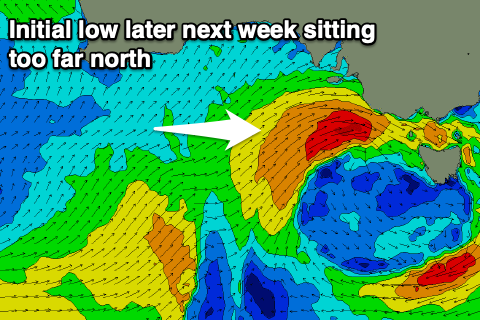
Winds will shift to the west on Thursday and Friday as the mid-latitude frontal progression pushes in from the west, with no size expected until Friday/Saturday. This will be due to an initial strong mid-latitude low sitting too far north to generate any decent swell.
It'll be really west and only impacting the Mornington Peninsula and with those average westerly winds. As the progression dips south-east across us we should see some better swell generated through our swell window, but we'll have to review this on Monday. Have a great weekend!


Comments
Well, this afternoon disintegrated nicely
Yeah I had written it off till strayya day wkend..
That system late next week looks like a beast & Tassie in for a treat on the way down with the Tasman low, then again as it maybe joins (feeds in energy?) to the front off the west coast of Tas...
Spinning lows in the Tasman and the eastern Bight - what season does that normally happen in?
With these sorts of forecasts it looks like Craig is on the payroll at the tub.
We’re overdue for some decent surf.
no complaining from west coast please. fucking westerly up until Christmas.
Get a few this morning NB? Looks like there might have been some peaky ones around on the MP.
Did you set up some food vans and make a $hedload of money Nick? It's been busy this side too, lots of people around.
had a check and it was peaky and kind of fun looking, depending where you look.
Yeah, peaky kinda swell. Some spots handle it ok. It’s always luck of the draw and generally only a low tide affair. These peaky swells always seem to lack the usual energy of our swells.
Haven’t really surfed with many more than usual suspects down this end due to there being hardly offshore days for all the fair weather surfers. Plenty of waves.
Interesting low tide setup at Portsea. Lotsa exposed rock!
pfffft. that's not lots of exposed rock. Honestly if you think that's lots i got a rock in central australia to sell you. that's a 3/10 amoutn of rock at best which isnt' a lot.
theres just too much hyperbole on this site these days with ben peddling his wares like a wsl commissioner.