Poor weekend, more options opening up next week
Victoria Forecast by Craig Brokensha (issued Friday 10th January)
Best Days: Monday until mid-afternoon, later Tuesday keen surfers, possibly Wednesday morning
Recap
There was plenty of swell left across both coasts yesterday with the prlonged SW groundswell easing slowly through the day, from 4-6ft on the Mornington Peninsula and the 3ft range on the Surf Coast. Conditions were poor around Torquay, improving into the afternoon as winds eased, while to the east, cleanish most of the day across selected spots.
Today the swell is on the way out and early was clean across the Mornington Peninsula with easing 2-3ft sets, 2ft across the Surf Coast swell magnets and also nice and clean. A change is edging in now from the west, with poor conditions due for a few days once it hits.
This weekend and next week (Jan 11 - 17)
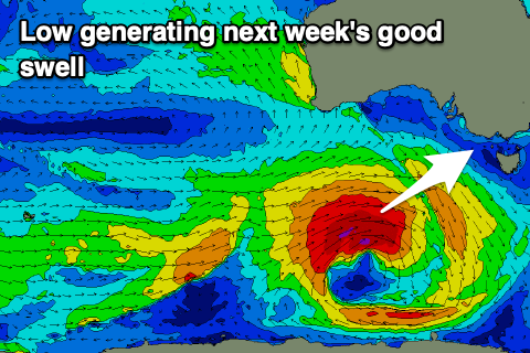
Looking at the coming weekend and it's not too flash at all. A deepening and likely 'bombing low' will develop late in our swell window today, south-west of Tassie, moving a little quicker east instead of stalling as was forecast on Wednesday.
This will result in a downgrade in the S/SW groundswell for Monday, but looking at the weekend ahead, a frontal change attached to the low will move through early tomorrow morning bringing strong SW winds, easing a little through the day.
A moderate sized mix of mid-period and windswell are due, building to 3-4ft on the Surf Coast into tomorrow afternoon and 5-6ft+ or so to the east, easing from a similar size on Sunday. Winds will remain average though and moderate to fresh out of the S/SW, weakening and swinging more S/SE through the day.
We are still due to see one final pulse of S/SW groundswell on Monday from a fetch of gale to severe-gale S/SW winds just within our southern swell window Saturday.
The swell might not be there in the early morning Monday but should fill in through the day and provide 3ft sets on the Surf Coast, 4ft to the east, a little smaller in the morning.
 Winds are looking great for the beaches across the state with a N/NE offshore, likely holding until midday/early afternoon ahead of sea breezes.
A weak trough moving through on Tuesday still looks to bring onshore SW tending S/SE winds with a low point in swell early ahead of a new building W/SW groundswell later in the day.
This swell has been upgraded since Wednesday, with the source being a tropical depression being absorbed into the westerly storm track from the southern Indian Ocean.
As it tracks south-east it will super-charge a frontal system moving in from the south-west, with a slow moving and strengthening fetch of W/SW gales due to move slowly through our western and then south-western swell windows on Sunday and Monday, finally dipping east-southeast under Tassie.
A moderate sized W/SW tending SW groundswell is due from these developments, kicking strongly Tuesday afternoon and peaking overnight/early Wednesday morning.
We should see the Surf Coast kick to an easy 4ft later Tuesday, easing from a similar size on Wednesday morning, 6ft+ to the east. The models are divergent on the local winds for Wednesday at this stage with EC looking great, but we'll have to go over this again on Monday. There's potentially a weaker follow up swell later week, but more on this Monday. Have a great weekend!

