Large, powerful swell inbound
Victoria Forecast by Craig Brokensha (issued Friday 20th December)
Best Days: Selected spots Sunday and Monday, next Saturday morning
Recap
Onshore winds and a small increase in weak swell yesterday, better today across all locations though full early with a new mid-period SW swell and 2ft sets on the Surf Coast, 3ft to occasionally 4ft to the east. The swell should strengthen a little more through the day with Cape Sorell peaking early this morning and winds are due to hold before shifting more N/NW into the evening.
This weekend and next week (Dec 21 - 27)
Tomorrow will be poor with a cool onshore change this evening bringing fresh and gusty SW tending S/SW winds to the coast tomorrow along with a small, drop in swell from today.
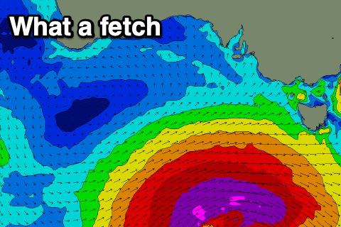
We then look to the large and deep low that's currently forming south-west of us today.
 There's been no real change to the strength and longevity of this system, with a fetch of severe-gale to storm-force W/SW winds developing initially in our south-western swell window later this afternoon and evening, pushing slowly east and more into our southern swell window tomorrow, only weakening once passing under Tassie tomorrow evening, but continuing to direct SW gales in our southern swell window until Sunday morning.
A large, pro-longed and long-period groundswell event will impact the state from Sunday through Tuesday, with the first and largest pulse of SW groundswell due to fill in Sunday.
At dawn the swell may be a little undersized, with it kicking in large and consistent from later morning and peaking into the afternoon.
The Surf Coast should build to an easy 6-8ft, with 10ft sets on the Mornington Peninsula, and I'd expect some of the regional swell magnets to be bigger again at the peak of the swell.
Unfortunately winds are still average and onshore but not as strong, with a moderate S/SE breeze, freshening into the afternoon.
Come Monday the swell will be more S/SW in direction and still large, easing from 6ft+ on the Surf Coast and 8ft to the east on the sets, though a slow moving high in from the west will continue to direct S/SE winds across Bass Strait, shifting more S'ly through the day.
Onshore SE winds will persist into Tuesday, strengthening through the afternoon kicking up a late increase in SE windswell, while in the morning the S/SW groundswell should be easing from 3-4ft on the Surf Coast, 3-5ft to the east owing to the southerly swell direction.
As touched on in the Christmas Warp, Wednesday morning will see winds go variable though with onshore winds at dawn it'll likely still be lumpy and not great, with a mix of small, weak, fading S/SW and SE windswell from 1-2ft on the Surf Coast and a similar 2ft on the Mornington Peninsula.
The end of the week looks poor with onshore S/SW winds kicking back in Boxing Day with no new swell, still onshore from the S/SE Friday with a new W/SW swell showing into the afternoon.
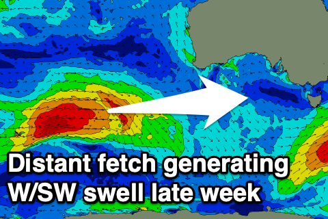
 This swell will be generated by a strong but distant front forming north of the Heard Island region tomorrow, projecting a fetch of W/SW gales through our western swell window, south-west of WA, weakening into Monday evening.
The swell is looking a little better than on Wednesday, with it due to build slowly Friday and peak later in the day to 3-5ft on the Mornington Peninsula, 2-3ft on the Surf Coast swell magnets but onshore.
Next Saturday morning looks better as the swell starts to ease from an inconsistent 2ft+ on the Surf Coast and 3-4ft on the Mornington Peninsula with a morning E/NE-NE breeze. We'll confirm this on Friday though. Have a great weekend!


Comments
Air temps just cracked 41.4 at Aireys Inlet, 43.6 at Cape Nelson, 42.7 at Port Fairy, and 44.9 at Avalon.
And we've still got a few hours until peak temps are due.
Hotter than hell in Melbourne at the moment with a nice coating of smoke from the NSW busfires driven by the northerlies.
Hopetoun in the Mallee hit 47.4 this afternoon
Was funny here, until about 1:30 it was still in low 30's on the coast, it had been a mellow morning and even quite pleasant in town early. A late max temp was predicted. Then about 2:30 the northerly wind hit, it's still going. Tried my own weather gauge at 4 and it was 33 on south side back garden, and 42 on verandah at the front which is north facing, so I'd say forecasts are pretty spot on, BOM revising up to 43 here on the coast.
Our house about low to mid 20's inside which is nice, no air con, usually on a really hot day it gets near 30 but the cool morning has made it quite pleasant although currently a furnace outside.
Looking at BOM aireys, currently 43 - it was 20 at 10am and 41 at 2pm, pretty fast rise!
By Sat evening it was back to jeans and jumper for me - ah Vicco, how I love you and all your changes
By Sunday arvo - well that was pretty solid! A check of the main name breaks at 6 and no one out on that stretch, really big rips out the back too.
How big?
Yorkes was pumping today. Started off manageable at one of the exposed spots in the park early and then in the space of about 10-15 minutes the period and size really jumped and it was time to call it.
Looked at it about 4-30 or so.
I’m calling a really consistent 6 ft+ , long powerful lines.
Real shame about that wind.
ten ft sets up here Ben.
big clean lines from the "south as it gets" angle
Mental Clam, guessing there were some good ones going down!
Ben asked how big - lots of south in the swell so everything was breaking wide & maybe changed how it looked, for eg I reckon I saw TP and it's bombie in the bay link up in one set, producing a very large right at outer Drainos! I'd go with 6 plus, and I reckon Bells was quite a bit bigger on the big Easter comp day with Toledo, JJF surfing incredibly waaaay out on the bowl that day.
It was weird too, in between sets there was a sea state producing head high waves & bigger, and every 5 to 10 minutes a real set would come in (or two sets close together) that were a lot bigger. Maybe a couple of these were 8, for the scale of the peeling wave and whitewater at one spot were large, 300m plus and this spot hasn't broken that well on bigger swells so maybe direction came into play. That last claim with some reservation, as there just weren't the people out there in the seascape to scale it, so you have to approximate based on which parts of the reef are lighting up/tide level.
Pity about the wind.
Awesome feedback guys. I was in SA on the YP as well and saw the swell kick from dawn, undersized early but then powering through by mid-late morning with bommies cloudbreaking in the distance. Good to see how the south direction performed with some breaks hardly breaking but others coming in very nicely.
The size at the offshore bommies looked huge. Impressive to see with the strong offshore adding to the drama.