A day for the beaches, followed by a large, powerful swell
Victoria Forecast by Craig Brokensha (issued Wednesday 18th December)
Best Days: Exposed beaches Friday, a handful of spots Sunday and Monday
Recap
Slow drop in size across the state yesterday with clean conditions on the beaches and 2ft+ sets on the Surf Coast, 3ft+ to the east, while today is clean again but small to tiny.
This week and weekend (Dec 19 - 22)
After today's hot weather we've got a temporary reprieve tomorrow before things heat up again into Friday.
A surface trough will bring a cooler and moderate to fresh S/SW change to the coast tomorrow along with a small increase long-range and inconsistent W/SW swell and small SW swell. It'll not be worth worrying about with 1-2ft sets on the Surf Coast swell magnets and 2-3ft on the Mornington Peninsula.
Friday is looking much better, not because of the winds but we've got a slight upgrade in a mid-period SW swell that's due to fill in.
The weak front linked to this swell is looking a touch stronger, with a favourable fetch of strong W/SW winds due to be generated through our south-western swell window today and early tomorrow morning before passing under Tassie.
The Surf Coast swell magnets should see 2ft+ sets, with 3-4ft waves on the Mornington Peninsula with a moderate to fresh NE morning breeze, shifting N/NW late afternoon and into the evening.
This will be ahead of a cool change and strengthening onshore S/SW winds Saturday, creating poor conditions as the swell eases.
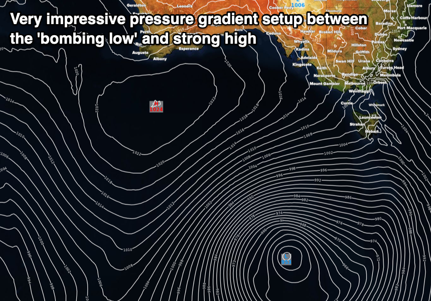
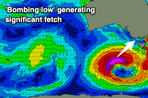
We then look to the 'bombing low' forecast for the Southern Ocean late week, with it deepening significantly in our south-western swell window before moving slowly through our southern swell window on the weekend.
For a storm to be classified as a 'bombing low' it has to drop 24hPa in 24 hours, with the southern most low of a pair of lows moving in from the south-southwest of WA due to just meet those requirements through Friday.

We'll see the low bottom out to a very impressive 953hPa and with a 1024hPa high pressure system squeezing its western flank, resulting in the development of a significant storm-force fetch of W/SW winds in our south-western swell window.
 The low will move slowly east while weakening slowly, projecting a fetch of severe-gale W/SW-SW winds more through our southern swell window before passing under Tassie and out of our swell window Sunday afternoon, prolonging the large swell event.
A large, long-period and powerful SW groundswell will be generated from the initial stages of the low, arriving early morning Sunday and filling in rapidly, peaking through the day to 6-8ft across the Surf Coast and 10ft on the Mornington Peninsula. There's the chance for the odd bigger cleanup set at times owing to the strength and size of the swell.
Unfortunately onshore S/SW tending S/SE winds will create average conditions across most locations, spoiling the large, quality groundswell.
Monday will remain poor as well with moderate S/SE tending fresher S/SW winds along with large, easing levels of S/SW groundswell from the 6ft range on the Surf Coast and 6-8ft to the east.
Unfortunately winds will remain poor and fresh from the S/SE on Tuesday as the swell continues to ease more steadily. These onshore winds will linked to the strong high edging in behind the low on the weekend.
Wednesday morning looks clean on the beaches, but small to tiny.
Longer term, the models are in agreement regarding a good frontal progression developing in the south-east Indian Ocean Sunday through early next week, producing a fun though inconsistent W/SW swell for later next week and weekend. We'll have another look at this on Friday though.


Comments
Circus + Food Stalls = Ma millions.
Retirement scheme still on track.
You'll be comfortably well off!
https://www.instructables.com/id/Krabby-Patty-Recipe/
Instagram will soon be flooded with images of Vic’s best wave once again, with the same people complaining about how crowded the joint is now days.
Yeah the Tulla pool loves these conditions! Only place that's offshore.
Ha! It’s only a matter of time Craigo