Picking the eyes out of a dud spud
Victoria Forecast by Craig Brokensha (issued Wednesday 11th December)
Best Days: Desperate surfers Surf Coast Friday and Sunday mornings, Monday morning, exposed beaches Tuesday morning
Recap
Poor surf across all regions yesterday with strengthening onshore winds and a mix of swells, a little bigger this morning but still generally poor.
This week and weekend (Dec 12 - 15)
The coming days are marginal at best but you may be able to hunt out a small, clean runner.
Cleaner conditions are expected tomorrow across the Surf Coast with an early W/NW breeze, but today's mix of swells are due to fade, leaving tiny waves. Winds will then shift SW mid-morning and strengthen from the S/SW into the afternoon.
A new SW swell is expected to fill in Friday, produced by a small and weak but persistent front moving through our swell window today and tomorrow.
 A small kick in size to the 2ft range is due on the Surf Coast, 3ft to occasionally 4ft to the east and a morning W-W/NW breeze will favour the former, shifting S/SW later morning and strengthening into the late afternoon.
Come Saturday a touch less size is due, with a secondary weak pre-frontal fetch of W/NW winds generating a small reinforcing W/SW swell to 1-2ft on the Surf Coast and 3ft to the east. There might be a touch more size into the afternoon but a morning W'ly breeze will shift S/SW later morning and freshen into the afternoon.
Sunday morning isn't looking too much stronger with a small 2ft wave on the Surf Coast, 3ft to possibly 4ft to the east with a morning W/NW wind, giving into S/SE sea breezes.
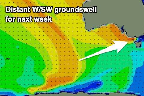
Come Monday our inconsistent long-range W/SW groundswell is still on track, with a tight and strong low forming north of Heard Island yesterday now spawning into a fetch of W/NW gales, pushing east-southeast through our distant swell window.
The storm will weaken slowly south-southwest of WA tomorrow, with the inconsistent groundswell due to arrive very late Sunday but peak through Monday. Inconsistent 3ft sets are expected on the Surf Coast swell magnets, 4-5ft to the east.
Winds look to have a W/NW tendency again but we may see more variable breezes on the Mornington Peninsula early but we'll have to review this on Friday. S/SE sea breezes are due into the afternoon so there may be a window just before these kick in.
Tuesday looks better with a N/NE offshore, but smaller, easing inconsistent swell from 3ft to hopefully 4ft on the exposed beaches.
Longer term there's nothing too significant on the cards but we'll reassess this Friday.


Comments
There is not one (1) northeast day in the 16 day forecast. So incredibly fuckt
Surely next week NE at some stages.. Getting hot..
"Oh! There's a big high coming"....well,yeh so's Christmas but at least we know when,exactly. The SSW event has been atrocious for S.A. coasts and worst of all around Victor. Nowhere good in Easterlies. Nowhere good in Westerlies. Nowhere good in Southerlies. And no Northerlies. Its an overcall to describe the last month as Average....but at least its not raining. On the upside....it just can't get any worse.