Make the most of the weekend
Victoria Forecast by Craig Brokensha (issued Friday 6th December)
Best Days: Protected spots tomorrow morning, exposed beaches from mid-morning Sunday
Recap
A continuation of pumping reef waves on the Surf Coast yesterday, and even hanging in bigger than expected this morning. Surf mostly to 4-5ft with favourable winds, bigger to the east but best in protected spots. Winds will start shifting W/SW late morning-midday so make the most of this morning.
All this constant wintery activity is due to the Sudden Stratospheric Warming event in early September.
This weekend and next week (Dec 7 - 13)
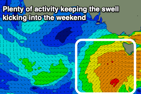
We've got plenty of swell on the cards for the weekend, with a new S/SW swell due to fill in this afternoon and hold tomorrow morning. This is being generated by a broad and final frontal system projecting a fetch of strong W/SW-SW winds through our southern swell window today, right off Tasmania.
Seeing the size that's still hanging in this morning we should see easy 4ft sets hanging in on the Surf Coast, likely up to 5ft on the swell magnets, easing slowly through the day and around the 6ft range to the east.
 Winds look great through the morning for protected spots with a W/NW breeze, shifting S/SW late morning and strengthening into the afternoon.
The swell will drop more rapidly through Sunday, down from 3ft on the sets across the Surf Coast, to 2ft into the afternoon and 4ft to the east, down to 2-3ft. Winds should become variable Sunday morning and tend E/NE, favouring the beaches to the east of Melbourne. The dawny will likely be lumpy and morning sick, improving mid-late morning and best ahead of the sea breeze.
Fresher N/NE winds are due Monday but the swell will be all but gone, tiny on the Surf Coast and 1-2ft on the Mornington Peninsula.
As touched on through the week, there's nothing significant for most of next week with a large blocking high deflecting any major swell generating systems. There may be a slight kick in size Tuesday from a tight but short-lived low on the weekend to our south-west but not above 2ft on the Surf Coast and with W/SW tending S/SW winds, S/SE Wednesday as it eases.
Later in the week a broader but weaker front forming south-west of us is forecast to clip the state later Thursday and Friday, bringing onshore winds and possibly an increase in mid-period SW swell though without any major size. Therefore make the most of the weekend's waves! Have a great weekend.


Comments
Best week to the start of summer non stop waves for 4 days ( not working made it even better) yeeeeeew
Not the biggest but has to be close to the best swell of the year for consistency. Seemed every other decent swell was wsw with big lulls between sets. This one pumped. My arms are farrked.
Feast or famine, surfed twice in 6 weeks in the east. Absolute shocker
Got around to it and now a subscriber. It's good to read these notes and see all of the forey again.
What a week, physically tired! I stopped to smell the roses on Wed arvo and the consistency was surprising, I counted sets in the 4-5+ft range arriving every 4 minutes and one poor bloke got destroyed paddling back out by one of those flyswat 6ft peaks - the set that got him was only 2 minutes after the last one.
Thanks VJ, and the longevity was due to the stationary nature of the progression, front after front on top of active sea states resulitng in so many varying pulses of large swell. A run to remember.
This arvo' s new swell is really pulsing in now. Already bigger than what was forecast. I can't remember a run of swells like this in summer ever.
And it was solid this morning, very big walls running wide. A bit more of a gap between sets & what I saw (and caught and got clobbered by) today maybe revises Wednesday arvo up a bit in size. Swell event of the year on SC?
Craig, why did it stay so strong for so long?
Some kinda solid sets on the peninsula but defiantly not lined up, more like large lumps of water. Size wise no idea but running wide, perhaps period wasn't refracting into your side?
The running wide ones were a good thing! Maybe a function of the tide. I did notice a couple of sets come up from the centre of the break rather than the classic SW (sliding from right to left). Maybe direction change.
WPort on your side would have had waves?
WP was 2ft and weak
Consistent lumpy and wind effected shit
Yep absolutely putrid. First forecasted offshore in 2+ weeks and it’s still straight onshore(even though south channel says otherwise)
Great run of swell. Very quiet where I was late morning yesterday at one of the main reef breaks. Seemed to be more consistent than normal. Mainly 4-5ft or so but there was one 7ft rogue that came out of nowhere. Crazy to have that size in December! Smaller today but still nice and consistent.
Sheet glass on the front. White caps on the back