Another good weekend of swell coming
Victoria Forecast by Craig Brokensha (issued Monday 18th November)
Best Days: Surf Coast tomorrow morning keen surfers, exposed beaches keen surfers Wednesday morning, Surf Coast Saturday and Sunday mornings, Monday
Recap
Great waves continued on the Surf Coast on the weekend, with the biggest increase in mid-period SW swell coming in a little above expectations and to 4-6ft on the magnets with favourable conditions most of the day.
Winds were only favourable for a short period yesterday morning before swinging onshore with a little less size, smaller again today as the mid-period swell eases but with cleaner conditions across all locations. Winds look as if they'll go S/SE early afternoon so try and surf now east of Melbourne.
This week and weekend (Nov 19 - 24)
The weekend's swell will continue to drop into tomorrow, but a mid-period reinforcing SW swell is due to fill in, keeping small waves hitting both coasts through the day, easing Wednesday.
This has been generated by a broad but unfavourably aligned fetch of pre-frontal W/NW winds slipping south-west of us last night.
 2ft+ sets should be seen on the Surf Coast swell magnets, 3ft to occasionally 4ft to the east though winds aren't too favourable. An early light W-W/NW breeze is due on the Surf Coast, SW elsewhere and swinging more S/SW through the day while increasing a touch in strength.
Wednesday will become cleaner on the exposed beaches with a NE offshore, but size wise it'll be minimal. Fading 1ft to maybe 2ft sets are expected on the Surf Coast, 2ft to possibly 3ft on the Mornington Peninsula. Get in early as the afternoon will be smaller and with sea breezes.
Thursday will be poor with a low point in swell energy along with strong N/NE winds, blowing out any tiny swell. A strong SW change is due into the afternoon but no major swell is expected behind this change, with onshore S/SW to S/SE winds Friday.
The forecast deepening of a mid-latitude front directly south-west of us late week looks to now occur under Tasmania, with no swell really due until a secondary better frontal system moves in under the country later week and into the weekend.
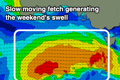
This broad and multi-staged frontal progression will start to the south-west of WA, with a great fetch of strong W/SW winds, with a few embedded gales forecast to move slowly east through our western swell window. The progression will weaken slightly Thursday evening before a secondary front fires up on its tail, projecting an additional fetch of slow moving W/SW winds towards us Friday and Saturday.
A moderate sized and prolonged W/SW swell event is expected, building Saturday and peaking Sunday before easing slowly from Monday.
Size wise we should see the Surf Coast reaching an easy 4ft (likely bigger) from late Saturday but more so Sunday, and 6ft+ to the east. Winds will favour the Surf Coast with a W/NW tending S/SW breeze on Saturday, W/NW early Sunday ahead of a weak S/SE change mid-morning. Monday again looks like the best day to the east with a variable E/NE-NE wind and moderate sized easing swell. We'll confirm this on Wednesday though.
Longer term there's plenty more activity on the cards for the end of next week, but more on this Wednesday.


Comments
Praise our lord and saviour we don’t live on the gold coast
Oi! Don't spoil the surprise for non-subscribers.
For them, it'll be death by a thousand paper cuts watching this unfold in two day increments.
Oh they don’t see that do they?
Feel free to delete, no probs..
Just having a larf.
Haha.
Our saucer which art in a colander, draining be Your noodles. Thy noodle come, Thy meatballness be done on earth, as it is meaty in heaven. Give us this day our daily sauce, and forgive us our lack of piracy, as we pirate and smuggle against those who lack piracy with us. And lead us not into vegetarianism or being on the Gold Coast, but deliver us from non-red meat sauce. For thine is the colander, the noodle, and the sauce, forever and ever. R’Amen
Haha, yes that looks awful, but I'd take that at the moment. It's been dead fucken flat here, as in not even an ankle-high ripple.
Can they read the comments in the forecast notes?
They can. Ben is just taking the piss but, haha.
a hit and run to Bells is looking pretty inviting
Looks like the wavepool forey!
Today was sweet. The odd 6ft set every now and the
Promising for tomorrow holding a bit of size..
Sorell is on the drop but.
Today was my day. I hate what’s on the cards for tomorrow, at least by time it’s knock off. Hot’n’hungry for small dying swell.
Just take some cans to the carpark and watch and assess :)