Smaller, less consistent swells from the west
Victoria Forecast by Craig Brokensha (issued Monday 28th October)
Best Days: Exposed beaches tomorrow morning and Surf Coast most of the day, Thursday morning keen surfers exposed beaches, later Friday exposed beaches, Sunday morning
Recap
A slow start to the weekend but a new swell filled in through the day Saturday, offering 3ft sets on the Surf Coast with generally clean conditions most of the day, holding 2-3ft yesterday and clean again through the morning. To the east the surf was bigger but average on the exposed beaches.
This morning we've got fun 3ft sets continuing on the Surf Coast with generally clean conditions and bumpy bigger waves to the east.
This week and weekend (Oct 29 – Nov 3)
It's good to be back again, though coming in a little cold in respect to the long-range and inconsistent W/SW groundswell due across the state over the coming days.
This swell provided large pumping surf in WA yesterday and has started to fill in across the South Australian coast, and the Cape Sorell wave buoy is picking up some energy in the 20s band from the fore-runners.
The swell should build slowly today but peak through tomorrow, with very inconsistent 2-3ft waves on the Surf Coast and 4-5ft sets to the east.
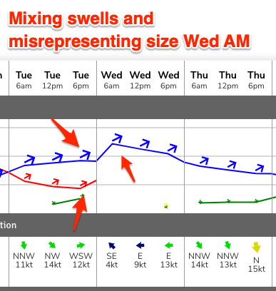
 The swell is then due to ease back slowly through Wednesday, and the models are misrepresenting the peak and over-forecasting the size, combining the long-range energy with a small mid-period swell from Tuesday into Wednesday.
Easing 2ft to maybe 3ft sets are likely on the Surf Coast and waves more to 3-4ft+ to the east Wednesday.
Coming back to the local winds and most locations should be clean tomorrow morning with a N'ly breeze east of Melbourne, N/NW on the Surf Coast and swinging more NW and then W/NW through the afternoon ahead of a late change as a trough moves through.
Unfortunately it looks like winds will linger out of the S/SE-SE into Wednesday morning in the wake of the change, creating bumpy conditions as the swell eases.
Thursday will be decent across the exposed beaches, but becoming blowy with a strong N-N/NE breeze with small fading 2ft sets on the Surf Coast, 3ft+ to the east.
 Friday morning will likely be a low point ahead of a new inconsistent W/SW groundswell into the afternoon and Saturday morning. This swell is currently being generated by a tight and distant polar low that's formed around the Heard Island region.
A fetch of severe-gale to storm-force but weakening W/SW-W winds are being generated in our far western swell window, with the low breaking down south-west of WA tomorrow.
Very inconsistent waves only to 2ft+ or so are due later in the day on the Surf Coast Friday as the swell fills in, 3-4ft to the east, peaking dawn Saturday to a similar 2ft+ and 3-4ft+ to the east.
Strong N/NE winds look as if they'll persist into Friday morning but the surf will be small to tiny, with winds later likely holding and easing from the N/NE (ideal for the late). Saturday looks a little dicey as a small trough moves through just before dawn bringing variable tending W/NW winds ahead of a more pronounced S/SE change. We'll confirm this Wednesday though.
The change will be linked with a broad but relatively weak and dissolving mid-latitude frontal progression moving in from the west later week. While looking good on the synoptic charts, the progression will be muddled and weak, with a broad fetch of strong W/SW winds forecast to be aimed through our western swell window under WA and the Bight from Thursday through Saturday.
We should see a moderate sized mid-period W/SW swell from the source but only likely reaching 3ft on the sets across the Surf Coast Sunday and 4-5ft to the east. Winds are a little up in the air but we may see an early offshore east of Melbourne Sunday, though we'll review this Wednesday.


Comments
Gary will spend all week seeking full exposure for this forey
Very odd swell this arvo. Very overlappy anywhere from 3-6ft