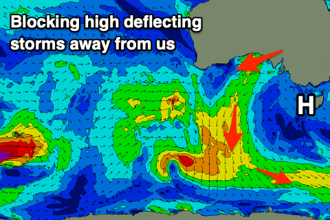
Average outlook continues
Victoria Forecast by Craig Brokensha (issued Wednesday 9th October)
Best Days: Keen surfers tomorrow, desperate surfers east of Melbourne Friday morning and Saturday mid-late morning
Recap
OK conditions for keen surfers around Torquay early yesterday morning with 2ft of swell and a lighter W'ly wind, deteriorating through the day and poor across all other locations.
Today we've got a poor quality swell with moderate to fresh onshore winds and no real quality surfing options.
This week and next (Oct 10 – 16)
These notes will be brief as Ben's on annual leave.
More of the same tomorrow, though the onshore wind looks to be a bit weaker in strength. A moderate S/SW breeze will spoil a new S/SW groundswell that's due to peak tomorrow morning, generated by a strong polar front moving through our southern swell window.
The Surf Coast should ease from 4ft on the sets (mostly 3-4ft) with 5-6ft sets on the Mornington Peninsula.
 The swell will ease through the afternoon and drop further Friday from 2ft+ on the Surf Coast swell magnets, 3ft to maybe 4ft to the east and winds will remain average and moderate from the E/SE, strengthening through the afternoon and evening, producing a building SE windswell.
There's a chance for more E'ly winds across both regions Friday morning, with better options on the Mornington Peninsula for keen surfers.
Strong E/SE winds through Bass Strait Friday afternoon and Saturday morning will produce a peak in SE windswell Saturday morning likely to a sloppy 3ft on the Surf Coast, 2ft+ on the Mornington Peninsula with winds poor and still fresh from the E/SE at dawn, but likely tending E/NE for a period up until midday before swinging back to the SE. While not great there should again be some OK peaky, though weak waves for keen surfers across the Mornington Peninsula.
Sunday will be cleaner with a NE breeze, though swell wise there'll be hardly anything left in the tank with a fading SE windswell on the Surf Coast from 1ft to maybe 2ft, similar in size on the Mornington Peninsula with a very long-range background W/SW groundswell.
There's no new significant swell due until later Tuesday and more so Wednesday when a long-range W/SW groundswell fills in.
The source of this swell will be a strong but distant polar low forming south-west of WA later this week, breaking down south of WA on the weekend.
A small to moderate sized swell is due, peaking Wednesday around 3ft on the Surf Coast and 4-5ft to the east, but a trough moving in from the west looks to bring onshore winds. More on this Friday.


Comments
Grrrrr. Frustration building!!!!
When was the last clean and solid Surf Coast swell? Seems like months ago.
Come on. This is shit for both coasts and ya having a whinge after your winter.
Keep these piddling swells and S to E winds blowing for a few more weeks please Huey.
Ha ha, yep, it's been an awesome late winter into spring period of waves on the southern parts of the east coast...
I spend my time between the surf coast and the northern beaches and let me tell you VIc surfers should thank their lucky stars every day! The surf coast has had numerous swells this year that the northern beaches would call swell of the decade for them !
You should see the SC on a good year
So true geek.
Go away, go away, go away High,
You root up the surf, you're not a nice guy.
You make it all choppy, and shitty as well.
We want the fronts, the north westers, and swell.
Oh dear velocityjohhno,
I hope your want a no show
To crave nor west and swell
Well sir
In my books
Thats one bit fat no no
Looks like I timed tearing my hamstring from the bone pretty well during the last decent swell on September 11...pumping then, lately, not so much. Makes me a little happier.