Small fun beachy options, large from late next week
Victoria Forecast by Craig Brokensha (issued Friday 5th July)
Best Days: Exposed beaches tomorrow morning and Sunday, Surf Coast Thursday and protected spots Friday into next weekend
Recap
Large easing surf on the open beaches yesterday, cleaning up through the day and good into the afternoon with the high tide and dropping size.
This morning the swell has almost halved in size with clean 3ft to occasionally 4ft waves on the Mornington Peninsula and 2ft+ sets to the west, though a bit all over the place.
Today’s Forecaster Notes are brought to you by Rip Curl
This weekend and next week (Jul 6 - 12)
We'll see the swell easing back further through tomorrow from a small 1-2ft on the Surf Coast magnets and inconsistent 3ft on the sets across the Mornington Peninsula (mostly 2-3ft). Winds will be great for the beaches with moderate to fresh N/NE winds.
Conditions will remain clean into Sunday with persistent and moderate to fresh N/NE winds as a very inconsistent and long-range W/SW groundswell fills in. This swell, discussed through the week isn't great and will favour the exposed beaches with the Surf Coast not likely to offer much over 1-2ft on the magnets, with 3ft to occasionally 4ft sets to the east. Expect long waits for these and be patient.
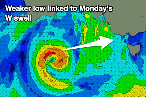
 The secondary closer-range W/SW swell for Monday looks even flukier now, with the mid-latitude low forming south of WA this afternoon now due to be smaller and weaker, while also strongest when north of our swell window.
No size is expected on the Surf Coast now, with fading and tiny 1-2ft waves Monday, and 3ft sets on the Mornington Peninsula. With winds swinging to the W/NW, it'll be a lay day.
From here it'll be a slow week with no swell of power or significance expected across the coast until later in the week.
A weak front moving across us Wednesday looks to generate a small weak W/SW windswell for later in the day but more so Thursday, but by the time this swell arrives a stronger front looks to move in and through Bass Strait Thursday morning, generating a stronger increase in mid-period W/SW swell.
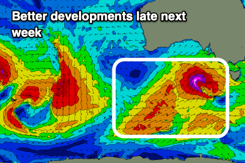
 It looks like we'll see the Surf Coast jump to 4ft, with 6ft+ sets to the east under gusty W/NW winds. This will be the precursor to a much more significant mid-latitude storm firing up under the country.
Latest updates have a significant fetch of storm-force W/SW-SW winds being projected right up and into us on Thursday and Friday, generating a very large and powerful SW groundswell for later Friday and more so Saturday morning.
The catalyst for this progression will be a node of the Long Wave Trough strengthening across the south-east of the country, bringing this large and windy swell. The models diverge slightly on the track of the storm-force winds, with ECMWF pushing it further north resulting in less size and cleaner conditions, but more on this Monday. Have a great weekend.


Comments
Craig the graph has gone into the stratosphere for next weekend 25 foot???
Yeah, the 18z run has gone out of control. 50-60kt winds projected right up and into Victoria, if it came off we'd be looking at one of the biggest swells in a few years. We'll see what coming updates have, and ECMWF isn't aligned.