Large swells and offshore winds enroute
Victoria Forecast by Craig Brokensha (issued Wednesday 8th May)
Best Days: Surf Coast Saturday, Sunday, Monday, Tuesday morning
Recap
Clean but tiny waves across the Surf Coast yesterday, bumpy and small to tiny to the east, while today started tiny and poor across most beaches. A strong W/SW change moving through this morning will kick up a poor and weak W/SW windswell this afternoon to 2ft+ on the Surf Coast and 3-4ft to the east. Winds are expected to shift back to the W/NW on dark, cleaning up the Surf Coast but the quality will be low.
Today’s Forecaster Notes are brought to you by Rip Curl
This week and weekend (May 9 – 12)
The front moving through this morning, generating this afternoon's increase in W/SW windswell will continue east this evening, with small, weak and easing surf tomorrow from 1-2ft at Surf Coast swell magnets and 2ft to maybe 3ft on the Mornington Peninsula.
 A strong N'ly tending N/NW wind will kill of the swell fairly quickly, while come Friday we'll see a change sweeping through bringing poor and gusty S/SW winds.
Our new SW groundswell for the afternoon is still on track with it being generated by the cold front bringing Thursday evening's change.
A good fetch of strong to near gale-force W/SW winds are being projected through our south-western swell window, south of WA, though the front will weaken tomorrow.
Size wise, the Surf Coast should build to 3-4ft into Friday afternoon with 5-6ft sets on the Mornington Peninsula, easing back Saturday from 3ft+ and 4-5ft+ respectively Saturday morning. Conditions will improve in protected spots with a morning W/NW breeze, possibly holding all of the day, though at least hanging from the W.
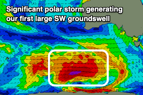
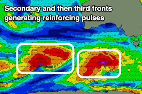
Sunday's new SW groundswell has been upgraded in size, with our secondary pulse for Monday with favourable winds also looking good.
Sunday's will be generated by a broad and intense polar low forecast to develop east of Heard Island this evening, projecting a fetch of severe-gale to storm-force W'ly winds through our south-western swell window, weakening a touch but still generating severe-gales along the polar shelf while tracking under the country Friday.
 This will produce a large, long-period SW groundswell that's expected to arrive Sunday morning and build rapidly to 6ft on the Surf Coast (8ft sets swell magnets) and 8ft+ on the Mornington Peninsula into the afternoon.
Winds are looking great for protected spots with an all day offshore W/NW tending NW breeze Sunday, persisting from the N/NW on Monday with a secondary reinforcing SW groundswell.
This secondary swell will be generated by a secondary polar front generating a burst of severe-gale to possibly storm-force W'ly winds on top the active sea state, keeping the Surf Coast up around 6ft on Monday morning (8ft sets swell magnets) and 8ft+ on the Mornington Peninsula, easing through the day.
Tuesday morning should be clean again on the Surf Coast with a W/NW offshore and the swell will steady with another reinforcing though moderate sized W/SW groundswell from a third strong frontal system firing up temporarily in our swell window south of WA on the weekend.
Longer term there's plenty more activity on the cards for later week, though not to the size of Sunday/Monday at this stage, but check back here Friday for more details.


Comments
Magic May returns!!
how big will tuesday be?
Probably 4-5ft+ at this stage on the SC.
still on track for 8ft sets Sunday on the SC swell magnets?
8ft bombs, yes.