Poor outlook for the coming week
Victoria Forecast by Craig Brokensha (issued Wednesday 1st May)
Best Days: Exposed beaches tomorrow
Recap
A drop in swell back to a small 1-2ft on the Surf Coast yesterday, best on the beaches with great 3-4ft sets on the Mornington Peninsula.
Today the swell has faded back further leaving tiny waves on the Surf Coast and 2-3ft sets on the Mornington Peninsula, though inconsistent.
Today’s Forecaster Notes are brought to you by Rip Curl
This week and weekend (May 2 – May 5)
The end of the week will remain on the small side though with favourable winds for the beaches tomorrow. A deepening and broad mid-latitude low in the Bight will direct moderate to fresh N/NE winds across the coast most of tomorrow, though a funky trough moving through during the morning may swing winds temporarily onshore (if so wait it out a couple of hours).
A small new mid-period W/SW swell is still expected tomorrow morning, generated by a weak mid-latitude front passing under WA earlier this week, with some long-range and inconsistent W/SW swell for the afternoon from the earlier stages of the front.
Size wise the Surf Coast magnets are only due to come in at 2ft, with the rare 3ft'er, with 3-4ft waves on the Mornington Peninsula, with the rare 5ft'er.
The swell will ease through Friday from 1-2ft on the Surf Coast and 3ft to possibly 4ft on the Mornington Peninsula as winds swing NW, limiting surfing options.
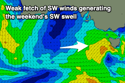
 Moving into the weekend, and the structure of the consolidating mid-latitude low to our west has changed and ultimately weakened, with a weak and short-lived fetch of strong W/SW-SW winds due to be projected through our swell window tomorrow afternoon and evening, with the front moving through Bass Strait early Saturday morning.
We'll see a poor onshore SW winds, likely W'ly early around Torquay but with a weak building swell to 3ft into the afternoon (small early), 4-5ft on the Mornington Peninsula.
Sunday will see lingering SE winds as the weak SW swell eases, possibly tending E'ly for a period on the Mornington Peninsula and more so Phillip Island.
Unfortunately the longer term outlook remains poor with a weak upper level blocking pattern taking hold next week. This will see any major swell generating systems (which there won't be) steered away from us along with persistent winds from the south-eastern quadrant.
This may break down next weekend, but it looks like we'll have to wait until the week of the 13th of May. More on this Friday.


Comments
come on Craigo, N/NE and 3-4ft with odd 5 ain't exactly poor :)
Hopefully the swell is there tomorrow, a touch dicey one but it'll be bigger than today.
Sure hasn't been a poor week down my way, last three days has been perfect size for the beachies, basically no wind, and banks all up and down the beach too spread the crew out..
Been super super fun.