Smaller week, best across exposed breaks
Victoria Forecast by Craig Brokensha (issued Monday 29th April)
Best Days: Exposed breaks tomorrow, later Wednesday and Thursday, Surf Coast Saturday
Recap
Pumping waves all weekend across the Surf Coast with Friday's very large and powerful SW groundswell easing from a more S/SW direction under offshore W/NW winds. Most spots dropped from 6-8ft, while a reinforcing swell kept 4-6ft waves hitting the magnets yesterday. To the east conditions were poor with the westerly winds and large surf.
Photo from Walk around G

Today the swell is now on the ease and the Surf Coast is great again, while the beaches to the east should improve into this afternoon as winds tend variable.
Today’s Forecaster Notes are brought to you by Rip Curl
This week and weekend (Apr 30 – May 5)
The outlook for this week has changed a little since last Friday when the models had a trough moving in later week bringing S/SE winds as a low developed off the southern NSW coast.
This isn't on the cards any more with the low now due to form to our west, with generally favourable though gusty winds along with small W/SW pulses, better into the weekend.
Our current SW swell will continue to ease in size and power through tomorrow, dropping from 2ft on the Surf Coast magnets in the morning, 3-4ft to the east. Gusty N'ly winds should persist most of the day, tending N/NW along the Surf Coast.
Wednesday looks small to tiny with background swell energy not likely to get above 1-2ft on the Surf Coast and possibly 3ft on the sets to the east. Winds will remain favourable for exposed beaches though with a moderate to fresh and persistent N/NE breeze.
A small pulse of inconsistent mid-period W/SW swell should be seen later Wednesday and more so on Thursday morning, generated by a weak front passing under WA and then into the Bight. A short-lived burst of strong W/SW winds will be seen, with the swell hopefully coming in at 2-3ft across Surf Coast swell magnets Thursday, with 3-5ft sets to the east.
 The beaches look to remain cleanest with a fresh N'ly wind, persisting all day, with N/NW breezes on Friday as the swell eases.
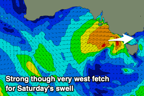
Moving into the weekend, and a broad multi-centred low forming to our west is expected to consolidate into one low pressure system Friday, producing a burst of strong to possibly gale-force W'ly winds through our western swell window, moving across us Saturday.
A very acute mid-period W'ly swell will be generated, likely peaking through the late morning Saturday to what looks to be at this stage to 3ft+ on the Surf Coast swell magnets, much smaller in more protected spots with 5-6ft sets on the Mornington Peninsula. Winds look to be fresh to strong out of the W/NW, easing and tending more W/SW into the afternoon.
Sunday may be clean again on the Surf Coast with an early W/NW breeze but the small, weak and fading.
Longer term there's nothing significant on the cards as an upper level blocking pattern looks to move in next week (opposite to the Long Wave Trough) resulting in no significant storm generating storms. More on this Wednesday though.

