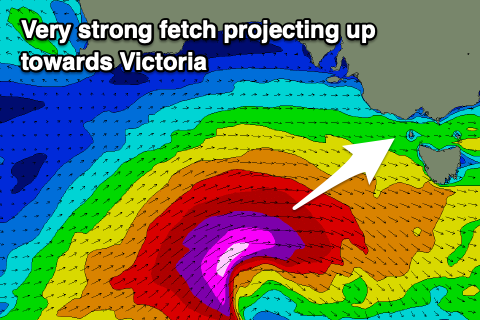
Easing surf ahead of a large, significant swell late week
Victoria Forecast by Craig Brokensha (issued Monday 22nd April)
Best Days: Both coasts tomorrow morning, Surf Coast Thursday and Friday morning, protected spots Friday PM, Surf Coast Saturday and Sunday morning
Recap
The surf dropped into Saturday a little quicker than anticipated though conditions were great for the beaches with excellent offshore winds and moderate sized sets.
Sunday started slow but a new inconsistent long-range W/SW groundswell built through the day with good options on the exposed beaches again.
Today our better though tricky W/SW swell has filled in with better waves on the Surf Coast to 3-4ft with light winds, bumpy and 4-6ft to the east.
Today’s Forecaster Notes are brought to you by Rip Curl
This week and next week (Apr 23 - 28)
Today's swell was generated by a very intense but southward dipping low in the Bight over the weekend and we'll see it drop fairly quickly into tomorrow.
Dawn on the Surf Coast should still reveal 2-3ft sets on the magnets, easing through the day with 3-5ft sets on the Mornington Peninsula. Winds are looking a touch dicey and possibly lingering out of the S'th but we'll likely see mainly variable breezes, remaining light onshore into the afternoon.
Wednesday looks to be a lay day as the swell bottoms out, clean on the Surf Coast through the morning with a W/NW offshore but tiny.
As touched on last update, a very long-period signal showing on the charts later Wednesday and Thursday was generated in our far far swell window, south-east of South Africa and won't have any real size attached to it.
Strengthening fronts moving in from the west though dipping east-southeast through our swell window will generate some better close-range SW swell, the first building later Wednesday and peaking Thursday, while a secondary front should generate an additional boost in size later Thursday.
 Size wise the Surf Coast should kick to 3ft on the sets Thursday morning, with 4-5ft sets on the Mornington Peninsula, while a secondary front pushing in under the Bight may kick the size a little bigger later in the day.
Winds on Thursday will be great all day for the Surf Coast and out of the NW tending W/NW as a very intense and deepening storm moves in from the west.
This will be the third in the progression of fronts, but we'll see it deepen significantly south of WA Wednesday, projecting a fetch of broadening severe-gale to storm-force W/SW winds through our western and then south-western swell window before moving in across us Friday.
A very large, powerful though windy long-period SW groundswell will be generated, building rapidly through Friday and at this stage, reaching an easy 8ft on the Surf Coast magnets and 10-12ft on the Mornington Peninsula into the afternoon but with fresh to strong W'ly tending W/SW breeze. With this Torquay will likely see a morning W/NW'ly but likely be a bit raw as the swell builds, large and victory at sea into the afternoon at exposed breaks.
We'll see a secondary front firing up on the back of severe storm, swinging winds back to the W/NW Saturday morning with a slight drop in size but still large surf on the Surf Coast and Mornington Peninsula. It'll also generate a large reinforcing swell which should then ease slowly from Sunday.
With this we should see great waves to finish off the Rip Curl Pro. Check back for the next update on Wednesday and any adjustments to the expected size due late week.


Comments
:)
Filipe just creased ones of his magic boards free-surfing rincon.....hope it wasn't a favorite.
Oh no!!
Vanda is fixing it up tonight, see insta story