Good waves for the beaches before things step up a couple of gears
Victoria Forecast by Craig Brokensha (issued Wednesday 3rd April)
Best Days: Beaches tomorrow afternoon, and Friday morning, early Sunday morning beaches and Surf Coast from mid-morning, Monday Surf Coast, protected spots Tuesday and Wednesday morning
Recap
Good to great waves across the state yesterday with Monday's swell easing back from the 3-4ft range on the Surf Coast and 4-5ft to the east as some early lump ironed itself out. The afternoon remain fun east of Melbourne with only some slight bump.
Today all locations were fun again but smaller and only to 2ft on the sets across the Surf Coast, a better 3ft to the east. A surface trough moving in from the west will bring a S'ly change early-mid afternoon.
Today’s Forecaster Notes are brought to you by Rip Curl
This week and next week (Apr 4 - 12)
The frontal system attached to the trough moving through this afternoon has strengthened a little more than forecast today in our south-western swell window and as a result we're looking at a bit more size on the coast tomorrow.
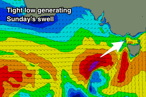
A tight fetch of W/SW gales produced directly south-west of us will produce a mid-period SW swell that may be seen on dark today but will peak tomorrow morning to 3ft on the Surf Coast and 4-5ft+ on the Mornington Peninsula.
As a result of the front being slightly stronger, the swing in winds back to the east will be a little delayed and the morning is now looking average with a moderate E/SE breeze, though the Mornington Peninsula and Phillip Island should improve through the afternoon as winds tend more E/NE.
A small E/SE windswell will also be generated for the Surf Coast owing to the easterly winds through Bass Strait, with both swells easing into Friday from a peaky 2ft. The Mornington Peninsula will be best with easing sets from 3ft under a N/NE offshore that will persist all day.
The swell will continue to fade Saturday making it a lay day with W tending SW winds and tiny waves on the Surf Coast.
 Sunday looks much better, with the first swell from the strengthening node of the Long Wave Trough moving in from the west expected to fill in.
This node will form towards WA, resulting in the development of an initial mid-latitude low over their way, dropping east-southeast through our swell window on Friday and generating a tight and intense fetch of gale to severe-gale W/SW winds directly west and then south-west of us.
A good pulse of W/SW groundswell should be seen, arriving overnight Saturday and peaking Sunday morning to the 4ft range on the Surf Coast and 6ft on the Mornington Peninsula (easing quickly through the day). With the low dipping east-southeast winds on Sunday look to become favourable for both regions with an early N'ly on the Mornington Peninsula (N/NW on the Surf Coast), tending NW through the mid-late morning and W/NW-W into the afternoon.
Behind this mid-latitude low we'll see the more significant frontal systems firing up, generating our large and powerful groundswell event into early next week.
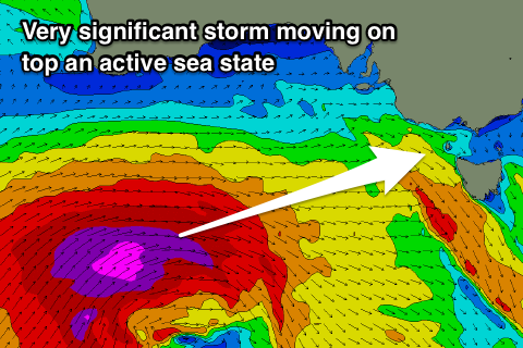
Around the Heard Island region today an intense polar low will form, projecting slowly east while generating gale to severe-gale W/SW winds before weakening while being steered up and under the country through the weekend.
Besides generating a building and strengthening W/SW groundswell for Monday it will also set up an active sea state for a much more significant polar storm to move over, with this front projecting a fetch of severe-gale to storm-force W/SW winds up through our swell windows on the weekend before moving across us Monday evening.
 A large long-period and consistent W/SW groundswell will be produced, arriving later Monday and peaking Tuesday morning to 8ft on the Surf Coast magnets and 10-12ft on the Mornington Peninsula. Ahead of this Monday morning should see good 3-4ft waves on the Surf Coast and 6ft sets to the east with a strengthening NW breeze ahead of the front proper.
Tuesday won't be as clean but protected breaks will be great with a morning W/NW breeze, tending SW later morning.
The easing trend will be slow as weaker frontal systems continue to back up the major swell generating storm, and winds will persist out of the SW Wednesday, likely W/NW early on the Surf Coast, shifting more E/SE Thursday We'll have a closer look at this and next week's swell again on Friday.


Comments
:)
Nice
Yeh and not a snapper hole in site either.
If it gets to six foot we better fill up our skis... wait on this isn’t the Goldie report is it?
Trying to remember the last time we saw a swell of this coming Tuesday’s strength with NE winds...
NE?
Yeah, you know that one we used to get
Not quite n, not quite e
Get ready to hassle Kelly, just said he's coming down early..
I'd absolutely love to surf with the goat, it's probably the last you'll ever seer him around the Bells area surfing, hope he likes to chat, cos if I see him, I'll introduce myself and have a chin wag. Best sports person/competitor ever in my opinion, a true legend of our generation and a positive ambassador of our sport.
He might chat but I will guarantee he’ll paddle inside you after every wave he takes off you
He's a fan of the spot west of the Otways, yeah?
Looks like we're in for a lean run of swell after next week's spike,
Craig, can you seen anything on the horizon for the start of the comp waiting period?
It's a long way away but at this stage it looks like we'll be eyeing off long-range and inconsistent W/SW groundswells with funky local winds at the start of the period. Take this with a grain of salt.
Cheers. Yep I realise it's a long way off...
A few days of 6ft plus Bowl would do the trick.