Strong easing groundswell, new swell for the weekend
Victoria Forecast by Craig Brokensha (issued Monday 21st January)
Best Days: Tuesday morning, keen surfers east of Melbourne Thursday morning, desperate surfers early Friday on the beaches, Surf Coast Sunday morning
Recap
A small bump in mid-period W/SW swell Saturday providing surfable waves for desperadoes, easing into Sunday with light workable winds again.
Today our strong new mix of W/SW and SW groundswell are filling in with light winds and 3ft sets this morning on the Surf Coast and 3-5ft sets to the east, but we've since seen the swell kick stronger. We should see the Surf Coast build to 4-5ft, with 6-8ft sets on the Mornington Peninsula as winds freshen from the S/SE.
Today’s Forecaster Notes are brought to you by Rip Curl
This week and weekend (Jan 22 - 27)
Today's strong mix of groundswells will peak this afternoon/evening and start easing through tomorrow. Conditions are looking better now with a variable wind that may have a light easterly tendency though overall with the strength of the swell we should see good waves and options across most of the state.
The Surf Coast should ease back from 3-4ft, with 5-6ft+ sets on the Mornington Peninsula, smaller into the afternoon and bumpy with fresh SE sea breezes.
Wednesday will be poor as a surface trough moves in from the south-west followed by a strong high resulting in moderate to fresh S'ly tending S/SE winds as the swell continues to ease.
Winds should swing around to the E/NE on Thursday morning with a mix of building SE windswell and small mid-period S/SW swell across both coasts.
 The mid-period energy will be generated by a weak polar front projecting towards Tasmania over the coming days, and is only likely to keep the Surf Coast around a weak 2ft, with 3ft+ sets to the east. The windswell from strong E/SE winds through Bass Strait looks small in the morning, though building later to 2-3ft on the Surf Coast, and 2ft on the Mornington Peninsula.
Friday morning will clean right up across most spots with a moderate to fresh N'ly wind ahead of a W'ly change as a strong mid-latitude starts moving in from the west. Size wise, the SE windswell looks to ease from a small 1-2ft on the Surf Coast, with a small, peaky and weak 2ft wave on the Mornington Peninsula.
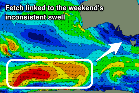
The mid-latitude low isn't expected to generate any major swell, but a stronger long-period SW groundswell is due to fill in through the day and peak into the afternoon.
This is already being generated by a strong polar low in the Heard Island region, though not favourably aligned until it moves further east and closer towards us. A better fetch of polar gales will be produced this evening and tomorrow before breaking down Wednesday, with the swell being a little inconsistent and building to 3-4ft on the Surf Coast and 5-6ft on the Mornington Peninsula.
A moderate SW wind looks to create bumpy conditions Saturday, possibly W'ly early around Torquay but without any size, then clean Sunday morning with a W/NW offshore as the swell eases.
Longer term we've got some fun W/SW swell on the cards for early next week, but more on this in Wednesday's notes.


Comments
Definitely a mix or something in the swell. Just had a look and some sets a big lumps hitting here and there. Looks kinda strange.
Yeah the SW energy should be more consistent, but with longer-period less consistent W/SW sets in the mix.
The summer of decent size & period swells continues.......IMO it's very unusual to get so many decent ground swells at this time of year on the westy and with the lite wind regime to get the most out of it as well. Keep it coming Huey!
Super fun 3ft reef waves this morning, more on the way......how good has this summer been.