Poor until next week
Victoria Forecast by Craig Brokensha (issued Wednesday 19th December)
Best Days: Both coasts Monday, Surf Coast Tuesday morning, beaches next Thursday morning
Recap
Workable waves across both regions yesterday with the swell dropping back from a fun 2-3ft on the Surf Coast with light to moderate morning onshore winds around Torquay, and a bumpy 4-5ft on the Mornington Peninsula.
This morning is smaller and back to 1-2ft on the Surf Coast and 3ft to the east with lingering onshore winds early, now swinging cross-offshore for the beaches to the east of Melbourne.
Today’s Forecaster Notes are brought to you by Rip Curl
This week and next week (Nov 20 - 28)
Unfortunately the outlook for the rest of the week and weekend remains poor, but we've got better waves due into next week.
The surf will continue to ease tomorrow with no decent groundswell due to be left across the state, replaced by a weak mix of windswells and onshore SW-SE winds, freshening through the day.
Friday is showing a little perk in size, but this is from a distant and not overly strong storm on the weekend and early this week.
I wouldn't expect anything much over 2ft on the swell magnets across the Surf Coast and 3ft to the east. Winds will keep conditions poor though with a fresh SW tending S'ly breeze, S/SW tending SW Saturday as the swell eases.
Sunday morning is looking cleaner on the Surf Coast with a light NW offshore but tiny easing surf, bumpy and small to tiny to the east.
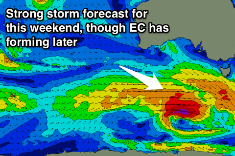
Of greater importance is some stronger and closer frontal activity that's forecast to develop under the country on the weekend.
 A relatively weak mid-latitude front moving in from the south-east Indian Ocean is expected to strengthen south-west of WA Friday afternoon and evening, generating a fetch of strong pre-frontal W/NW winds, followed by post-frontal severe-gale W/SW winds, strongest when south-west of us Sunday.
This will be the followed by a broad though weaker front, generating strong W/SW winds on its tail.
The track and aim of the initial strong storm isn't ideal and EC has it deepening later in our swell window (so I've put a buffer on the expected size), but we should see a good new SW groundswell building through Monday, peaking into the evening and easing slowly through Tuesday and Wednesday, slowed with the reinforcing mid-period energy.
The Surf Coast is expected to build 3ft+ by dark Monday, with 4-5ft+ sets on the Mornington Peninsula with offshore N'ly breezes as it slowly increases, giving into a shallow mid-late afternoon change (or sea breezes), which ever comes first.
Tuesday (Christmas morning) is looking good at this stage on the Surf Coast with an early W/NW breeze, and easing 3ft+ sets on the Surf Coast and 4-5ft+ waves to the east. Onshore S/SE winds look to move in Wednesday as the swell continues to ease, likely cleaner on the beaches Thursday but smaller again.
Check back Friday for a better look at next week's swell when the models will be more aligned regarding the expected size.


Comments
Thanks Santa!