Poor quality and easing swells as winds slowly improve
Victoria Forecast by Craig Brokensha (issued Friday 23rd November)
Best Days: Both coasts Sunday and Monday mornings, Tuesday morning Surf Coast, Wednesday morning Surf Coast, Thursday both coasts
Recap
Good fun waves on the exposed beaches yesterday morning with a slight bump in swell to 3-4ft and N'ly winds, small and fun to 2ft on the Surf Coast. A strong onshore change moved through into the afternoon creating poor conditions and kicking up a large stormy windswell this morning.
Protected spots on the Surf Coast are the only real option for desperate surfers.
Today’s Forecaster Notes are brought to you by Rip Curl
This weekend and next week (Nov 24 – 30)
The severe-low that's responsible for all this wild weather and snow in the mountains is now sitting off the Gippsland Coast and we'll see it sit there through tomorrow before slowly tracking off to the north-east Sunday.
This will result in poor persistent onshore winds across the coast tomorrow, strong from the S/SW though abating through the day.
We'll see the SW windswell easing back from a weak 3-4ft on the Surf Coast and 5ft on the Mornington Peninsula, smaller Sunday and down from 2ft and 3ft max, respectively.
A very inconsistent mid-period W/SW swell should also be in the mix Sunday but the models are over-forecasting and combining it with the easing windswell and I wouldn't expect any decent size at all on either coast.
Winds should improve though, but only for the Surf Coast with a W/SW-SW breeze, locally W/NW around Torquay through the morning.
So all in all it's not a great weekend of surf at all.
The surf will become small to tiny into Monday with average lingering SW winds.
 Conditions will finally clean up for the exposed beaches on Tuesday with an E/NE offshore but size wise, there'll be nothing of note at all. Maybe just a 1-2ft background signal.
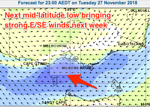
Our next increase in swell looks to be another stormy number as another mid-latitude low moves in from the west.
This system will sit further north and not be like the current low, with a weak SE windswell likely to build overnight Tuesday and peak Wednesday morning, easing thereafter as the low pushes further east Thursday.
Our better W/SW groundswell for later in the week and next weekend are still on track but local winds look to be a bit of an issue. Check back on Monday for an update on when we'll next see a decent surfable day, and have a great weekend!


Comments
Looks like I picked a good weekend to be the scorer at junior cricket and do the BBQ at little athletics!
Totally!
Ahhhhh, more junk! If this is a indication of what's to come........it's gonna be a long slow summer over here on the westcoast.
Hey Craig, the charts are looking very interesting for this time next week. The return of an angry looking cutoff low may finally produce another winteresk large long period swell for Vicco and we'll be into the first week of December!