Plenty of swell with limited windows of clean conditions
Victoria Forecast by Craig Brokensha (issued Monday 12th March)
Best Days: Torquay region early Wednesday and Thursday mornings, Saturday both coasts
Recap
Clean conditions but only small to tiny leftover waves across magnets Saturday, tiny and onshore yesterday.
Today some new swell has started to build, though only weak mid-period energy and with onshore winds. Later today some stronger groundswell is due, but the bulk of the energy is due tomorrow.
Today’s Forecaster Notes are brought to you by Rip Curl
This week and weekend (Mar 13 - 18)
During the weekend we saw a strong polar front projecting a fetch of W/SW gales through our south-western swell window, with a secondary fetch firing up on its tail last night and through this morning.
This has generated a moderate to large sized SW groundswell for tomorrow morning, with a slightly smaller reinforcing pulse for later in the day/Wednesday morning.
We should see the Surf Coast coming in at 4-5ft tomorrow with 6ft to occasionally 8ft sets on the Mornington Peninsula.
 Winds will be average though and fresh from the SW, with a very slight chance of lighter W/SW winds at dawn around Torquay.
The swell is due to be a touch smaller Wednesday and back to the 4ft range on the sets across the Surf Coast and 6ft on the Mornington Peninsula. Winds will be a touch better with weaker W/SW-SW winds across all region, more than likely light out of the W/NW around Torquay early morning.
Thursday will be slightly smaller again with third reinforcing pulse of SW groundswell overnight Wednesday due to keep fun sized sets the Surf Coast.
This reinforcing swell is being generated by a fetch of W/NW gales sliding in from the south-east Indian Ocean, weakening while approaching Tassie today.
We should see the Surf Coast easing from 3ft to occasionally 4ft at magnets, with 5-6ft waves on the Mornington Peninsula. Winds will persist from the W/SW tending SW, with early W/NW breezes around Torquay.
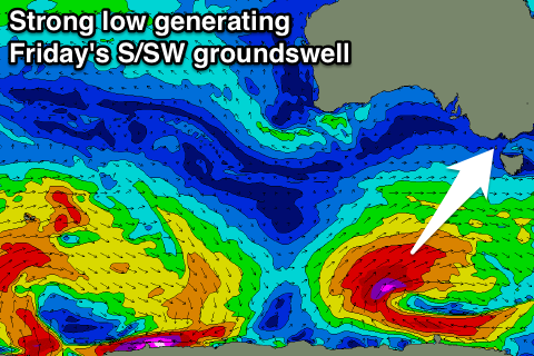
As touched on in Friday's update, one final pulse of large S/SW groundswell is due late week as a vigorous polar low forms south-west of Tassie tomorrow evening.
We'll see a great fetch of severe-gale to storm-force W/SW-SW winds projected up towards Tasmania, ideally through our southern swell window, generating a large long-period S/SW groundswell for Friday.
The Surf Coast should come in at 5-6ft with 8ft sets on the Mornington Peninsula with less than ideal SE-E/SE winds as a high moves in Thursday afternoon and through Friday.
Saturday looks much cleaner on the beaches with a N'ly offshore but the swell will be on the ease from 3ft to occasionally 4ft on the Surf Coast, down to 2-3ft, with easing 4-6ft waves on the Mornington Peninsula.
Longer term the swell will continue to fade through Sunday and Monday next week, while we may see another strong node of the Long Wave Trough moving in from the west, bringing large surf, but more on this Wednesday.

