Great beachy waves tomorrow, fun Friday morning with lots of swell for next week
Victoria Forecast by Craig Brokensha (issued Wednesday 7th March)
Best Days: Both coasts Sunday and Monday mornings, Tuesday morning Surf Coast, Wednesday morning Surf Coast, Thursday both coasts
Recap
Poor conditions across all locations yesterday with gusty onshore winds and a mix of swells.
Today we've got much better conditions across all locations with a variable breeze on the Surf Coast and 2ft of SE windswell, with clean 2-3ft of easing SW swell to the east of Melbourne.
Today’s Forecaster Notes are brought to you by Rip Curl
This week and weekend (Mar 8 - 11)
Our good new S/SW groundswell for tomorrow is still on track and winds are now looking better for the Surf Coast as well.
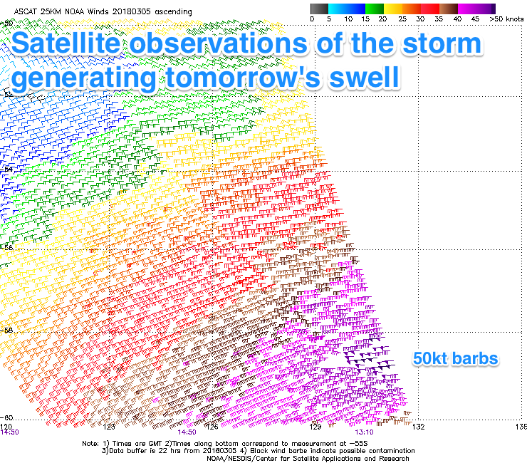
 A vigorous polar low has generated a fetch of severe-gale W/SW winds in our southern swell window with a couple of storm-force 50kt barbs picked up by satellite.
This longer-period and strong S/SW groundswell should fill in overnight and peak tomorrow to a strong 3ft+ on the Surf Coast tomorrow and 4-5ft on the Mornington Peninsula.
A light variable wind from the NE should favour the beaches across both regions through the morning ahead of afternoon sea breezes.
Our secondary reinforcing S/SW swell for Friday has been downgraded a little with the secondary tight low linked to it forecast to be much weaker.
We'll just see the S/SW swell easing from 2ft+ on the Surf Coast magnets early in the day and 3-4ft on the Mornington Peninsula with similar variable winds from the E/NE during the morning.
Into the weekend we'll see the surf become small to tiny with local offshore N'ly winds Saturday, best on the Mornington Peninsula with easing 2ft+ surf. The Surf Coast will be tiny.
A low point is expected Sunday with early light NW winds ahead of an onshore change.
Next week onwards (Mar 12 onwards)
As touched on last update, a node of the Long Wave Trough will strengthen and stall across us next week, resulting in back to back frontal systems firing up in the Southern Ocean.
The first major system will develop south of WA on Saturday afternoon, projecting a fetch of W/SW gales towards Tasmania, generating a moderate sized swell for later Monday, peaking Tuesday.
A secondary broader storm swinging in from the south-east Indian Ocean will produce similar strength winds and a secondary pulse of moderate sized SW groundswell for Wednesday.
Trailing weaker frontal activity should then keep wave heights up into the end of the week, but the main issue at this stage are the local winds.
With the LWT positioned just a touch east of Victoria we'll see less favourable SW winds through most of the week, likely W/NW early each morning around Torquay. More on this Friday.


Comments
Fill in overnight wed/thurs or thurs/fri?
Key word tomorrow ;) "fill in overnight and peak tomorrow".