Small clean surf tomorrow, good again Saturday
Victoria Forecast by Craig Brokensha (issued Monday 26th February)
Best Days: East of Melbourne tomorrow and early Wednesday, Saturday morning both coasts
Recap
Clean conditions early Saturday morning though only tiny on the Surf Coast and best east of Melbourne before a change moved through.
This change brought a lift in swell Sunday but with poor onshore winds which have swung more E'ly this morning creating workable options east of Melbourne with fun sized sets.
Today’s Forecaster Notes are brought to you by Rip Curl
This week and weekend (Feb 27 – Mar 4)
The swell generated by the weekend's change is currently on the ease and will continue to drop through tomorrow, reinforced by a long-range swell as winds improve further.
The Surf Coast will be small to tiny with a mix of easing S/SW and SE windswell from 1-2ft, while the Mornington Peninsula looks best with inconsistent 2-3ft sets.
A N/NE wind should persist most of the day east of Melbourne with N tending N/NW winds on the Surf Coast.
Wednesday looks to be back to 1-1.5ft on the Surf Coast with leftover 2-3ft waves east of Melbourn under an early fresh N/NE tending NW breeze, strong from the W/NW into the late afternoon.
 This strengthening westerly wind will be associated with an intense but weakening mid-latitude low pushing in from the west, with only small weak SW windswell due in its wake Thursday along with gusty SW winds.
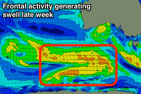
Into the afternoon some new SW groundswell should fill in, produced by a strong polar low that's currently just east of the Heard Island region.
A fetch of strong to gale-force W'ly winds will be projected along the polar shelf over the coming two days, broadening while weakening and passing under the Bight tomorrow and Wednesday.
The swell should build Thursday afternoon, reaching 3ft into the afternoon on the Surf Coast and 4-5ft+ on the Mornington Peninsula, holding Friday to 3ft and 4-5ft respectively.
Later in the day Friday and Saturday morning the lagging long-period energy from the strongest part of the storm around Heard Island should keep similar sized but less consistent sets hitting both coasts with improving conditions.
A high will move in quickly Friday though winds will likely linger from the S-S/SE creating average conditions, much better Saturday with morning NE winds.
Come Sunday a surface trough will bring an onshore change with smaller easing surf.
Longer term winds should improve through early next week with a possible fun SW swell, but more on this Wednesday.


Comments
tomorrow going to be flat around surf coast i gather as its gone completely flat now?
Yep, as per the forecast. A little background swell may provide waves to 1-1.5ft.