Poor summer surf
Victoria Forecast by Craig Brokensha (issued Monday 29th January)
Best Days: No good days, possible Saturday morning
Recap
Bumpy but workable waves across the exposed beaches on Saturday, coming in around 3-4ft on the Mornington Peninsula, smaller and average on the Surf Coast.
Yesterday was the cleanest but smaller with easing 2-3ft sets with great weather.
This morning a trough moving in from the west has been delayed a little with early offshore winds but tiny waves on the Surf Coast and small 2ft'ers to the east.
Today’s Forecaster Notes are brought to you by Rip Curl
This week and weekend (Jan 30– Feb 4)
The surface trough linked to today's change is currently moving through the Shipwreck Coast and we'll see it pushing through midday/early afternoon across the Melbourne region, thus bringing the start of our run of poor conditions.
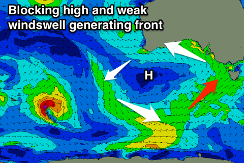
This trough will continue pushing east as a strong high moves into the Bight, stalling resulting in a persistent fetch of onshore winds being aimed into us from tomorrow through until at least the weekend.
Gusty and terrible S/SW winds are due through tomorrow and Wednesday, spoiling a new W/SW swell that's due to build later today. This swell isn't that great, generated by a weak mid-latitude frontal system pushing up towards WA over the weekend.
 We're only looking at 2ft+ waves on the Surf Coast (2-3ft 13th Beach) tomorrow, with similar amounts of windswell building into the afternoon, with 4ft waves on the Mornington Peninsula.
The swell will ease Wednesday under those persistent gusty S/SW tending S winds.
A weak polar front pushing up past the south-east corner of the high will produce a small kick in S/SW swell through later Wednesday and Thursday morning, but the size looks limited.
We'll likely see 2-3ft waves on the Surf Coast and 4ft+ sets to the east, easing through Thursday though with moderate S/SE winds, similar Friday though possibly more SE as the swell continues to ease.
Moving into the weekend we may see a period of more variable winds on Saturday before onshore winds redevelop. Swell wise though, only a small S/SW swell is due, generated by another weak polar front. The Surf Coast will likely come in around 2ft, with 3-4ft sets to the east.
Longer term the strong high responsible for the persistent onshore winds will very very slowly move east, and this will result in no significant swell and a very slow improvement in winds through early-mid next week. Therefore the outlook remains poor unfortunately.

