Slowly easing surf with improving winds over the weekend
Victoria Forecast by Craig Brokensha (issued Wednesday 24th January)
Best Days: Keen surfers both coasts tomorrow morning (less so Friday morning), beaches Saturday morning, and swell magnets across the state Sunday morning
Recap
Fun waves across the Surf Coast yesterday with light winds through the morning and 3ft sets at magnets, while to the east conditions were a little bumpier.
Today we've got a good new W/SW swell with light W'ly winds favouring the Torquay reefs with bumpy 3-4ft sets and workable onshore E/SE winds to the east of Melbourne along with 6ft surf.
Today’s Forecaster Notes are brought to you by Rip Curl.
This week and weekend (Jan 25 – 28)
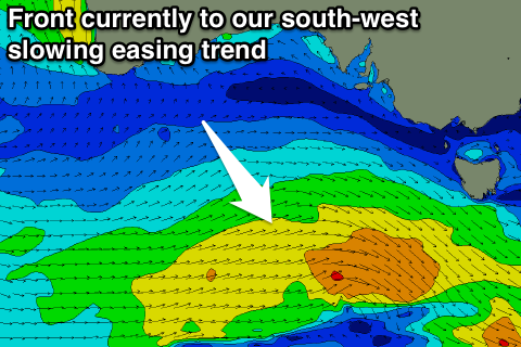
Today's W/SW groundswell should hold most of the day before easing off slowly through the coming days, slowed slightly by secondary weaker mid-latitude font that's currently west of Tasmania.
We should see the Surf Coast easing from 3ft+ tomorrow (more consistent 3-4ft at 13th Beach) with surf in the 5ft range on the Mornington Peninsula.
 Friday looks smaller with easing 2-3ft sets on the Surf Coast and 3-5ft on the Mornington Peninsula, down further from 2ft and 3-4ft respectively Saturday morning.
A long-period signal in the mix Friday won't provide any decent size, with this swell being generated way over around Heard Island, in our far swell window.
Light to moderate SE winds are expected tomorrow, creating workable waves for keen surfers across select locations, while Friday looks to see similar SE winds, that may be slightly fresher.
Lighter and more variable winds on Saturday morning from the east should open up fun waves across the exposed beaches, while a fresh N/NE'ly Sunday will straighten things right up, though the Surf Coast will be tiny, and the Mornington Peninsula small and easing from 2ft to occasionally 3ft.
Next week onwards (Jan 29 onwards)
Some new W/SW groundswell is due into early next week, generated by a relatively weak but slow moving polar front projecting towards WA later this week, moving under the Bight over the weekend.
Unfortunately a trough associated with the mid-latitude frontal progression will move in Monday, creating poor conditions as the swell builds and peaks Tuesday. More on this Friday though.

