Great waves across exposed breaks tomorrow
Victoria Forecast by Craig Brokensha (issued Wednesday 17th January)
Best Days: Both coasts Thursday, magnets Friday morning
Recap
A mix of swells around 2-3ft on the Surf Coast yesterday with light winds, favouring the beaches through the morning, while the Mornington Peninsula saw fun but lumpy surf to 3-4ft.
A new inconsistent long-period W/SW groundswell pulsed initially through the day, but today we're seeing the strongest pulse, with infrequent 3-4ft waves across the Surf Coast magnets, smaller to 3ft elsewhere and around 4-6ft on the Mornington Peninsula.
Cape Sorell is still strong with the swell due to hold all day but with developing sea breezes.
Today’s Forecaster Notes are brought to you by Rip Curl
This week and weekend (Jan 18 - 21)
Today's inconsistent SW groundswell should ease back through tomorrow from an infrequent 3ft on the sets across magnets on the Surf Coast and 4-5ft on the Mornington Peninsula.
 Conditions will be great though with local offshore winds across both coasts persisting until mid-afternoon before possible late sea breezes develop.
Friday will be smaller with fading 2ft sets on the Surf Coast and 3ft to occasionally 4ft waves on the Mornington Peninsula with early N'ly winds (N/NW Surf Coast) giving into an afternoon S/SW change.
There's been no change to the weekend's poor conditions with small fading surf under S'ly winds on Saturday and SE winds on Sunday as some new small SW swell starts to fill in. We may see more variable breezes Sunday morning with maybe 1-2ft sets on the Surf Coast and 3ft+ waves to the east.
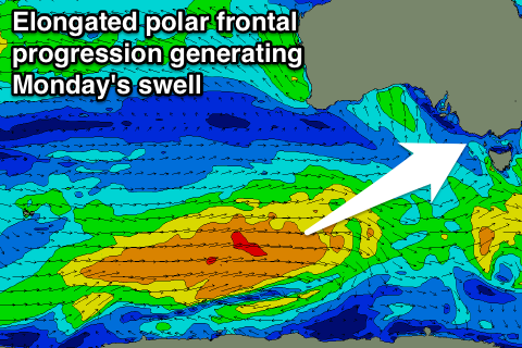
The swell will fill in more properly on Monday, generated by a broad and elongated fetch of strong to near gale-force W/SW winds moving slowly through our swell window from the Heard Island region, under the country over the weekend.
The Surf Coast should see good 3ft waves on Monday with the odd bigger one likely at magnets and 4-5ft+ sets on the Mornington Peninsula.
Winds unfortunately look onshore at this stage, persisting into Tuesday with a possible secondary swell pulse, but more on this Friday.


Comments
G'day Craig,
From Gary's well sheltered watching position behind a keyboard, it *feels* like today's swell came in a bit under - around the 1 Gary mark and not all that straight on the surf coast against more of a 1.5 Gary forecast. And this is with an impressive period spike on the Cape Sorrell buoy.
(Gary may also be mistaken as he's not actually there having a look himself)
How come? Distance of the source, direction, etc?
Wasn't a great swell for anywhere except WA in the end. Yeah distance of the low from the Victorian coast and the strongest fetch was aimed slightly away. Swell is strong now and coming in around 1.25 Gary's.
As can be seen here.. solid 4ft. There's a dude on the inside in that first shot.
Thanks Craig, it's not always about the size (unless you're talking about being an Elite Athlete, in which case it's all about the size of your legs)
One can have plenty of fun with a single Gary when it's nice as rigid as shown in those photos.
XOXO, G