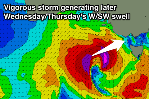
Great looking period ahead
Victoria Forecast by Craig Brokensha (issued Monday 18th December)
Best Days: Exposed beaches tomorrow morning, Surf Coast keen surfers later Wednesday, Thursday morning, both coasts Friday and Saturday mornings
Recap
Fun waves on the Surf Coast Saturday with a good sized W/SW swell and morning offshore wind, giving into sea breezes which started to affect the surf early afternoon.
Sunday was poor across all locations with an onshore SE breeze, though a reinforcing swell helped keep wave heights up around a similar size to Saturday.
This morning the swell was smaller and easing, mixed in with a small SE windswell on the Surf Coast, coming in at 2ft around Torquay and 2-3ft at 13th Beach with light morning offshores. The Mornington Peninsula was also clean with fun surf to 3-5ft.
Today’s Forecaster Notes are brought to you by Rip Curl
This week and weekend (Dec 19 – 24)
Moving into tomorrow, our current swell will continue to ease, leaving tiny waves on the Surf Coast and small fun 2ft sets early on the Mornington Peninsula with a N/NE breeze, swinging NW ahead of a mid-late afternoon W/SW change.
This change will be linked to a vigorous polar frontal progression developing under the country, as a strong cold low that's currently over WA dips south-east and interacts with an inland surface trough.
This will draw moisture into the already volatile low, resulting in the re-intensification of the storm, with a fetch of severe-gale to storm-force W/SW winds due to be generated in our western swell window tomorrow afternoon through Wednesday morning.
 The strength of this system has been upgraded since Friday, and with this an upgrade in the expected swell.
Wednesday morning is expected to start tiny on the Surf Coast, average to the east with a moderate to fresh W/NW wind, but a strong kick in size is due through the afternoon, building to 3ft+ later in the day on the Surf Coast and 6ft on the Mornington Peninsula though with W/SW winds.
A peak in size is due early Thursday morning to 3-4ft on the Surf Coast and 6ft+ on the Mornington Peninsula and the Surf Coast reefs will be best with a morning W/NW breeze, ahead of S/SW sea breezes.
The swell will ease slightly Thursday afternoon and into Friday morning ahead of a new increase in SW groundswell through the afternoon.
A secondary strong polar front generating a fetch of polar W/SW gales mid-week will produce this new swell, with the Surf Coast expected to pulse back to 3-4ft into the mid-late afternoon and 6ft+ on the Mornington Peninsula under a NW tending S/SW breeze. The Mornington Peninsula may see lighter N'ly breezes through the morning, but we'll review this Wednesday.
Similar winds are due Saturday morning as the swell drops back slowly from 3ft+ and 6ft respectively, and we may see a third weaker polar front generating a reinforcing SW swell for Sunday/Monday though with what looks to be poor S/SW winds as a high moves in from the west. More on this Wednesday.


Comments
Big change in conditions at PI this morning. Pumping beachies this AM:

Small and weak this afternoon (via our new Woolamai surfcam!):

How do we access the new woolamai cam it isn't coming up for me
Haven’t added it to the main menu yet (still doing some testing) but there’s a link underneath the other Vic cams.
Or, click here: https://www.swellnet.com/surfcams/woolamai
WOW These Pics are better than being there. How soon before it's Operational?
It is operational. Just not on the main website menu. But click the link above or follow the thumbnail links at the bottom of the other Vicco surfcams and you'll be able to watch it.
Was looking very nice this morning before the onshore change hit!

Looks like it cleaned up late following the afternoon t'storms and onshores. How's the image quality for 9:15pm too! These new low-light cameras are great.
Cape Sorell is flying.. though this swell is mainly from the NW, generated by this significant pre-frontal NW fetch..
Nought showing on the Peninsula this morning! Still early days though.
