Onshore winds and easing surf, with better waves from Friday
Victoria Forecast by Craig Brokensha (issued Monday 4th December)
Best Days: Surf Coast Friday, Saturday and Sunday mornings
Recap
Poor conditions all weekend with a building windswell through Saturday, with plenty of size into Sunday and decent winds for super protected breaks. Everywhere else was a write-off.
Today the swell has dropped considerably as the surface trough linked to the weekend's weather weakens to our east.
If you were surfing Lorne Point yesterday, we've got some hi-def vision recorded from our Lorne surfcam during the morning and afternoon. Watch through it below. You can also watch this surfcam live here: http://swllnt.com/LorneCam
Today’s Forecaster Notes are brought to you by Rip Curl
This week and weekend (Dec 5 - 10)
As touched on last week's outlook, this week isn't great for surfing at all until Friday.
We should see a new SW groundswell filling in today, peaking this afternoon and easing through tomorrow. The swell is showing on the Cape Sorell buoy and should ease from 2ft on the Surf Coast, with 3-4ft sets on the Mornington Peninsula.
Winds will remain average though and out of the SE at dawn, maybe tending more E/SE through the morning before freshening into the afternoon. Try the southern end of the peninsula and similar protected breaks if you're desperate.
Onshore winds will linger into Wednesday from the S/SE, tending SW as a deepening surface trough in the Tasman Sea dips south towards us. There'll be no decent swell left with fading 1-1.5ft sets and 2-3ft waves on the Mornington Peninsula.
 Into Thursday an approaching front will swing winds NW and offshore for the Surf Coast, but there'll be no swell left.
This front will bring with it a small increase in local windswell and mid-period W/SW swell for Friday, generated as it passes under the country. The front will be quite weak and as a result we're only due to see surf to 2ft to occasionally 3ft on the Surf Coast magnets, with 4-5ft sets to the east.
Winds look favourable for the Surf Coast with a morning W/NW breeze, possibly holding Into the afternoon with another approaching front.
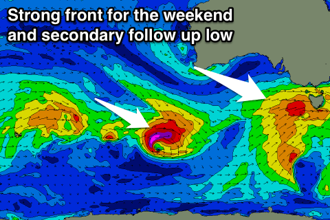
This front will have more substance and generate a good sized W/SW groundswell for the weekend, building through Saturday and peaking Sunday morning.
At this stage we're looking at 3ft+ waves on the Surf Coast and 5-6ft waves on the Mornington Peninsula with an early W/NW breeze, with a secondary follow up swell from a tight trailing low, but we'll have a closer look at this Wednesday.

