Small to moderate swells continue
Victoria Forecast by Craig Brokensha (issued Wednesday 25th January)
Sign up to Swellnet’s newsletter and receive the Victorian Forecaster Notes and latest news sent directly to your inbox. Upon signup you'll also enter the draw to win a surf trip to P-Pass for you and a mate (this is the last week to enter). It doesn’t get much easier so click HERE to sign up now.
Best Days: Early Surf Coast Thursday morning, both coasts Friday morning and early Saturday, Monday morning both coasts
Recap
Bumpy 2ft waves around Torquay early yesterday while everywhere else was poor and onshore, building in size with a stronger onshore change mid-morning.
This morning winds were lighter and more variable on the coast, but with no true offshore conditions were still a touch bumpy and lumpy.
Torquay was around 2-3ft, while 13th Beach is seeing bigger 3-4ft sets, while the Mornington Peninsula was solid and around 5-6ft.
This week (Jan 26 - 27)
Today's pulse of W/SW swell was expected to be the strongest due this week, with secondary fetches of pre-frontal W/NW winds currently moving under the country just maintaining small to moderate amounts of swell through tomorrow and Friday.
The Surf Coast should persist around 2ft+ (2-3ft 13th Beach) with 4ft+ sets on the Mornington Peninsula tomorrow and Friday with no true offshore, but workable winds.
A moderate to fresh W/SW breeze is due across most spots tomorrow, but the Torquay region should see an early W/NW'ly.
Friday should see improving conditions across all coasts through the morning (probably best mid-late morning east of Melbourne) with a variable wind developing ahead of weak sea breezes.
This weekend onwards (Jan 28 onwards)
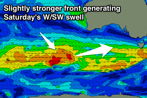
 A slight kick in power is due on Saturday, produced by stronger W'ly gales developing in our western swell window, south-west of WA today.
This should see slightly stronger sets on the Surf Coast to 3ft at magnets and 4-6ft on the Mornington Peninsula.
Conditions are expected to be clean on both coasts early with a light local offshore wind, but a shallow onshore change is due late morning, increasing through the afternoon.
Into Sunday a more consistent and slightly bigger W/SW swell is due to fill in, generated by a relatively weak but persistent fetch of strong W/SW winds from south-west of WA, all the way towards us through our western swell window into Saturday.
The swell is due to build through Sunday, reaching 3ft+ on the Surf Coast into the afternoon and 6ft on the Mornington Peninsula, easing back from 3ft and 5-6ft respectively Monday morning.
Winds on Sunday are a little tricky. They're looking variable before dawn but coming up from the SE just after dawn, leaving limited options for a wave. Check back Friday for an update on this.
Monday is looking great though with a N'ly offshore as the swell eases, tending more W'ly through the afternoon.
Into Tuesday a much better and stronger W/SW groundswell is due across the state, produced by a slow moving and intense mid-latitude low. At this stage the swell looks to build Tuesday, peaking later and easing Wednesday with W-SW breezes. More on this Friday.

