Not too many options for a decent wave
Victoria Forecast by Craig Brokensha (issued Wednesday 18th January)
Sign up to Swellnet’s newsletter and receive the Victorian Forecaster Notes and latest news sent directly to your inbox. Upon signup you'll also enter the draw to win a surf trip to P-Pass for you and a mate (there's only 2 weeks left to go). It doesn’t get much easier so click HERE to sign up now.
Best Days: Early Friday both coasts, Sunday morning keen surfers east of Melbourne, Monday morning east of Melbourne
Recap
Clean conditions yesterday morning with easing 2ft waves on the Surf Coast and 3ft on the Mornington Peninsula, while an overnight onshore change strengthened into this morning creating poor conditions across all locations with no decent groundswell.
This afternoon we should see a mix of W'ly groundswell and short-range W/SW swell building, but winds will remain poor.
This week and weekend (Jan 19 - 22)
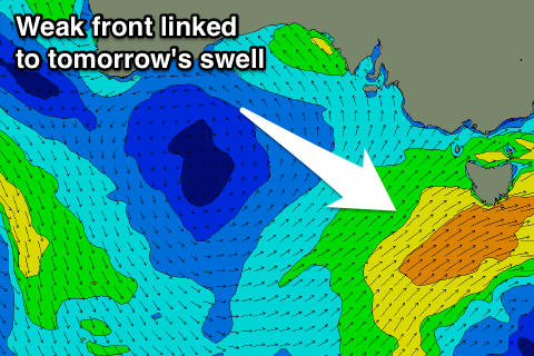
This afternoon's mix of W'ly and W/SW swell are due to peak early tomorrow. The better W/SW swell has and is still being generated by a cold front that's currently pushing across Tasmania.
 We should see 2-3ft sets on the Surf Coast, easing through the day and 4-5ft+ waves on the Mornington Peninsula. Conditions are still looking average with a moderate SE'ly tomorrow morning, but this should ease and tend more E/SE, with a possible window of OK conditions east of Melbourne as it does so. Sea breezes will then kick up into the afternoon again.
Friday morning is still looking clean, but you'll have to be quick as local offshore winds are due to give into an onshore change mid-morning.
The Surf Coast is only due to be small and easing from 2ft on the sets, with 3ft+ waves on the Mornington Peninsula.
Friday's change will be linked to a low forming off the East Coast and won't be related to any swell producing system.
With this even smaller surf is due Saturday and with onshore S/SW tending S/SE winds.
Our small mix of long-period W'ly swell and W/SW swell for Saturday afternoon and Sunday is still on track, but both these swells will struggle to provide much size at all on the coast.
The W'ly swell has been generated in our far swell window in the southern Indian Ocean, while some weak fronts moving under the country will produce some small to tiny and more consistent surf Sunday.
The Surf Coast will struggle to reach 1-2ft at magnets, while the Mornington Peninsula should see 2-3ft sets.
A light E'ly breeze should favour the eastern end of the peninsula through the morning ahead of sea breezes.
Next week onwards (Jan 23 onwards)
Longer term Monday should be cleaner with a N'ly offshore but the swell will remain small, while a strong cold front pushing through Tuesday should kick up a small to moderate sized W/SW swell for the afternoon and Wednesday (along with poor winds).
Beyond this small levels of W/SW swell are due to persist, but more on this Friday.


Comments
How small will the surfers be Saturday morning?
All different sizes Gary, all different sizes............... Should be the same on Sunday and everyday after that till the end of time itself Gary.
Sorry Hanko, I don't understand your comment. I'm not familiar with all the surf lingo yet.
Hako - thanks for the laugh. Gherkin you need to pay better attention to your questions...
Hi Shkeg. My surf couch says smaller surfers make the surf look bigger. I'm just hoping Saturday's surfers are small enough to give us regular sized surfers some more size to work with.
was better than expected this morning - wind eased off a bit
Yeah expected the winds to ease and surf to improve as noted above :)
Thanks Craig, yep good call - end of holidays alot less guys were out today on surf coast too