Variable period ahead with fluctuating winds and average swells
Victoria Forecast by Craig Brokensha (issued Wednesday 9th November)
Best Days: Both coasts Thursday morning, east of Melbourne Friday morning and Saturday morning
Recap
Good waves on the Surf Coast again yesterday with a building W/SW groundswell and light offshore winds before a shallow change moved through. This provided fun waves into the evening.
This morning the swell was still strong and from a more SW direction, with 3-4ft sets on the Surf Coast and 5-6ft waves on the Mornington Peninsula with a light variable wind. This was creating clean fun conditions at most spots.
This week and weekend (Nov 10 - 13)
Our current swell event will continue to ease through the coming days, and winds are looking a little better tomorrow morning. A weak southerly pressure gradient should result in variable winds through the morning with easing 2ft+ sets on the Surf Coast and 3-4ft waves on the Mornington Peninsula.
Friday is looking less favourable with small leftovers on the Surf Coast and a SE breeze, while the Mornington Peninsula should see a light E'ly but with inconsistent 3ft sets.
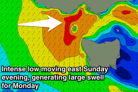
The forecast for the weekend is still average with a deep mid-latitude low expected to deepen and stall to our west during Saturday before moving across us Sunday and Monday.
Strong E/SE winds overnight Friday should produce a small E'ly windswell for Saturday morning on the Surf Coast but to no size, maybe 1-2ft max.
The Mornington Peninsula should see inconsistent 2-3ft sets, fading through the day and winds will be favourable for a period with NE tending NW breeze, freshening into the afternoon as the low dips moves in from the west and dips south.
 Now the positioning of the low is crucial for when we'll see swell generated from it moving into our coast.
The more north, the less swell, but at some stage Sunday we should see a fetch of SW gales wrapping around the backside of the low and through our swell window, generating a building W/SW swell.
This looks to be more so Sunday afternoon and along with strong W/SW winds.
With SW gales pushing through Bass Strait overnight Sunday, a peak in large but mid-period SW swell is expected Monday morning to around the 6ft range on the Surf Coast and 8ft+ on the Mornington Peninsula.
Strong W/SW winds will persist on Monday with only a slim chance of an early W'ly around Torquay, cleaner Tuesday with much less size.
Longer term there's nothing too major on the cards, but check back here Friday for an update on Sunday and Monday's forecast.


Comments
And the Cape Sorell buoy is back!
http://www.bom.gov.au/products/IDT65014.shtml
its a beautiful thing isnt it. Any word on what happened?
Buoy simply lost transmission, so it needed to be replaced.
What about the nepean buoy? has there been any waves since it was taken from us, will we get it back? I'd like to get back into surfing again.
Caught up in bureaucracy by the sounds:
Vicports Wave & Tide Information
Coming Soon
We're re-developing our Wave, Wind & Weather web pages with a brand new look & feel and will have them available soon. In the meantime we've negotiated with the previous supplier, Port of Melbourne Corporation, to restore access to the old Wave, Wind & Weather pages. We're aiming to have these pages available in the near future. Your patience is appreciated.
Yep got the same response.
Corporate double-speak for "we'll do it once there is a viable business case that directly demonstrates how the effort in restoring it will map to a revenue stream that aligns with our new business strategy"