Average tomorrow, fun Wednesday and Thursday across both coasts
Victoria Forecast by Craig Brokensha (issued Monday 26th September)
Best Days: Surf Coast late morning onwards tomorrow, both coasts Wednesday and Thursday, Friday Surf Coast, Saturday Surf Coast
Recap
Fun waves Saturday with an easing swell and clean conditions across all locations. Sunday was slow with an inconsistent W/SW groundswell and W'ly wind leaving Torquay with the cleanest but generally smallest waves to 2ft or so.
Today good clean conditions were seen across all beaches with yesterday's increase in W/SW groundswell on the ease. 13th Beach continued to see 2-3ft sets though, 2ft around Torquay and 3-4ft on the Mornington Peninsula.
This week (Sep 27 - 30)
Tomorrow will start slow across the Surf Coast with inconsistent 1-2ft sets and an offshore NW tending W/NW breeze.
Through the day an inconsistent W/SW groundswell should fill in with 2-3ft sets at magnets, but these spot will be bumpy with the westerly wind. The Mornington Peninsula will be average all day as sets build from 3ft or so towards 4-5ft.
Wednesday will be better as winds swing from the N/NW to N/NE, favouring both coasts.
A drop in swell is expected through the morning from 2ft on the Surf Coast and 4ft on the Mornington Peninsula. Later in the day though we may see a new W/SW groundswell arriving, with it due to peak Thursday.
This has and is still being generated by a strong front pushing towards WA and then through the Bight this afternoon and evening. A fetch of W/SW gale to severe-gales are being produced, in our western swell window, with the swell due to come in at a good 3ft+ at exposed breaks on the Surf Coast and 4-6ft on the Mornington Peninsula.
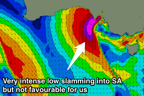
 Conditions will vary as an intense low pressure system developing across South Australia moves in from the west, swinging winds from the NE to NW through the day. This should favour both coasts at stages through the day.
The structure of this low isn’t ideal at all for swell production with storm-force S/SW winds slamming into South Australia, with no real fetch in our swell window.
As the low moves closer though a fetch of S/SW gales may just be within our swell window, producing a W/SW swell for Friday afternoon and Saturday morning. We'll have to review this again on Wednesday though.
Winds should be favourable from the N/NW Friday, with W'ly winds moving through Saturday as the low pushes further east.
Longer term there's nothing too major on the cards with an inconsistent W/SW groundswell for early next week, but more on this Wednesday.


Comments
Thanks Craig. Very interesting period coming up, all the forecast sites have something different thurs-sat. Going to be some serious flooding too around the state
Yeah it's a very dynamic and severe system, will have to track really closely and the rain totals are pretty insane.