Poor surf tomorrow, improving Friday, small and clean on the beaches Saturday
Victoria Forecast by Craig Brokensha (issued Wednesday 21st September)
Best Days: Thursday mid-morning into the early afternoon, locations to the east Saturday, Surf Coast Sunday morning and Monday
Recap
Good clean 3ft waves across exposed breaks on the Surf Coast most of yesterday with N'ly tending N/NW winds, while the Mornington Peninsula was in the 4-5ft range.
Today variable winds have created clean conditions across both coasts but early we feel in between swell pulses with smaller 2ft+ waves on the Surf Coast and 4ft sets on the Mornington Peninsula. A new inconsistent W/SW groundswell has since increased on the Cape Sorell buoy is now showing across the coast, as pictured below. Get out there ASAP though before those winds come up from the south.
This week and weekend (Sep 22 - 25)
Tomorrow will be poor as the surface trough linked to today's increasing onshore winds continues further east, directing fresh S/SW winds into us.
Today's building W/SW groundswell should ease back to 2-3ft on the Surf Coast and 4-5ft on the Mornington Peninsula.
Friday will become much better as winds tend light and variable through the morning with a small new W/SW swell. This swell is being generated by an unfavourably tracking and aligned fetch of NW gales through our swell window. Small 2ft waves are due on the Surf Coast with 3-4ft+ waves on the Mornington Peninsula. Dawn won't be the go, with conditions due to become cleanest mid-late morning.
Into Saturday small fading surf is expected from 1-2ft on the Surf Coast and 3ft+ on the Mornington Peninsula with N/NE winds. Therefore head to the beaches east of Melbourne.
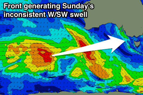
 Into Sunday a new inconsistent W/SW groundswell is due to fill in, produced by a strong mid-latitude frontal system that fired up north-east of Heard Island and is currently weakening south-west of WA. The front will push through the Bight while continuing to weaken and then passing across us early Sunday.
An inconsistent W/SW groundswell is due, coming in at 2-3ft at swell magnets on the Surf Coast and 4-5ft+ on the Mornington Peninsula. Conditions will be best to the west though with a W/NW tending W/SW breeze. Keep in mind though the places offering the cleanest waves on the Surf Coast will be smaller and not as exposed to the W/SW energy.
Next week onwards (Sep 26 onwards)
Sunday's swell should ease back into Monday under NW tending W/NW winds, with small to moderate levels of W/SW swell due to persist Tuesday and Wednesday from mid-latitude frontal activity under WA early next week.
A stronger increase in W/SW groundswell is on the cards for Thursday as a stronger mid-latitude front develops, but more on this Friday.


Comments
Can I suggest the forecast notes undergo an overhaul to a video clip. Just watched Channel 7 weather and if you can get a Jane Bunn type forecaster to present the notes website hits would skyrocket.
Im hearing ya Junk, i cant get enough of the Bunnsta
Haha, would you watch if I was on the big screen :p
No chance Craig, I think you know that.
Livinia Nixon please
She really used to flaunt it on WIN
Hi Craig, my car was just stolen from Juc. I have just posted a photo to you on insta could you/swellnet post it. Thanks
Thats terrible Superfish. Keys hidden at the usual spot?
Thats terrible Superfish. Keys hidden at the usual spot?
Yea but by my gf ... fuck. Anyone around JUC appararently there has been numerous thefts from the carparks so don't do it.
On a slightly heart breaking note ... I have a colourful 6'0 bat tail single fin in there which I got for $300 which is gone ... If anyone could keep their eyes out I would genuinely pay all my money for it .. has so much sentimental value. After snapping all my boards in Portugal the thickie survived the dreamiest couple months in morocco ...
Best to invest in one of those code lock things I think. Its happening too much fucking pricks.
Here's the deets, hope you get everything back superfish!